IMAGES TAKEN NEAR TO
Mermaid Way, MALDON, CM9 5LA
Introduction
This page details the photographs taken nearby to Mermaid Way, CM9 5LA by members of the Geograph project.
The Geograph project started in 2005 with the aim of publishing, organising and preserving representative images for every square kilometre of Great Britain, Ireland and the Isle of Man.

There are currently over 7.5m images from over14,400 individuals and you can help contribute to the project by visiting https://www.geograph.org.uk
Image Map (Loading...)


Getting Data...Please wait
Leaflet Map data © OpenStreetMap
Images are licensed for reuse under creativecommons.org/licenses/by-sa/2.0
Notes
- Clicking on the map will re-center to the selected point.
- The higher the marker number, the further away the image location is from the centre of the postcode.
Image Listing (7 Images Found)
Images are licensed for reuse under creativecommons.org/licenses/by-sa/2.0
Image
Details
Distance
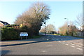
1

Mundon Rd Maldon
This roundabout is on Mundon Rd Maldon where it is intersected by Limebrook Rd and Park Drive
Image: © Glyn Baker
Taken: 2 Dec 2006
0.13 miles
2

The entrance to Maldon Town Football Club
The club was established in 1946 and they have been using this ground in Park Drive since 1994.
Image: © Robert Edwards
Taken: 29 Apr 2008
0.14 miles
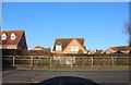
4
Poulton Close at the junction of Mundon Road
Image: © David Howard
Taken: 23 Feb 2019
0.17 miles

6
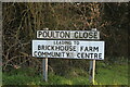
Signs for Poulton Close, Maldon
The odd thing about these signs is they weren't made much after the 60's but the houses were built recently.
Image: © David Howard
Taken: 23 Feb 2019
0.17 miles
7
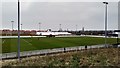
Wallace Binder Ground
Home stadium of Maldon and Tiptree FC.
Image: © Stuart Shepherd
Taken: 24 Mar 2018
0.18 miles