IMAGES TAKEN NEAR TO
Quayside Industrial Estate, MALDON, CM9 5FA
Introduction
This page details the photographs taken nearby to Quayside Industrial Estate, CM9 5FA by members of the Geograph project.
The Geograph project started in 2005 with the aim of publishing, organising and preserving representative images for every square kilometre of Great Britain, Ireland and the Isle of Man.

There are currently over 7.5m images from over14,400 individuals and you can help contribute to the project by visiting https://www.geograph.org.uk
Image Map
Images are licensed for reuse under creativecommons.org/licenses/by-sa/2.0
Notes
- Clicking on the map will re-center to the selected point.
- The higher the marker number, the further away the image location is from the centre of the postcode.
Image Listing (36 Images Found)
Images are licensed for reuse under creativecommons.org/licenses/by-sa/2.0
Image
Details
Distance
1
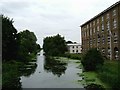
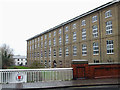
Bentalls Factory on Chelmer and Blackwater Navigation
The Bentalls factory, now converted to offices, is home to ICS Triplex Ltd. Bentalls began operating in about 1795 and their successors finally closed for good in 1984. They produced all kinds of manufactured goods, especially farm machinery. In the early twentieth century they even tried automobile manufacture; apparently only one 1908 example survives http://www.itsaboutmaldon.co.uk/bentall/bentall_car_story1.shtml . Read all about the company at http://www.itsaboutmaldon.co.uk/bentall/.
Image: © Glyn Baker
Taken: 13 Aug 2005
0.12 miles

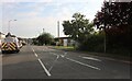
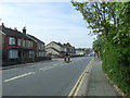
3
Junction at Heybridge
Where The Street meets Hall Road
Image: © Clint Mann
Taken: 11 Dec 2001
0.16 miles
4
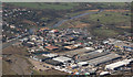
Aerial view of Maldon
This area of Maldon has a lot of industrial buildings.
The Combined Military Services Museum can be seen.
Image: © terry joyce
Taken: 6 Mar 2009
0.16 miles
5
The Street, Heybridge
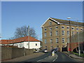
The building in the centre of the image is a former factory, now converted into offices.
Image: © Malc McDonald
Taken: 20 Apr 2013
0.17 miles
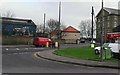
6
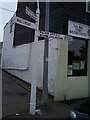
Direction Sign ? Signpost on the B1022 the Street in Heybridge
Located on the southwest side of the junction of the B1022 The Street and Hall Road in Heybridge parish. 3 arms, 1 broken, and gas lamp finial, now lost. A Maldon Iron Works post that was originally fitted with a gas lamp. When photographed one arm was broken - still the case in 2020 - and the pillar was severely cracked at the top.
Milestone Society National ID: EX_TL8507
Image: © John V Nicholls
Taken: Unknown
0.17 miles
8
The Caueseway (B1018), Maldon
Looking south west.
Image: © JThomas
Taken: 27 Apr 2017
0.17 miles
9
Bentall's Warehouse
Alongside the Chelmer & Blackwater Navigation at Maldon.
The inscription on the plaque on the side wall reads: Erected in 1863 by Edward Hammond Bentall. Iron Founder and Agricultural Implement Manufacturer, to hold up to 15,000 Machines awaiting export.
Image: © terry joyce
Taken: 19 Dec 2011
0.17 miles