IMAGES TAKEN NEAR TO
Rope Walk, MALDON, CM9 5EB
Introduction
This page details the photographs taken nearby to Rope Walk, CM9 5EB by members of the Geograph project.
The Geograph project started in 2005 with the aim of publishing, organising and preserving representative images for every square kilometre of Great Britain, Ireland and the Isle of Man.

There are currently over 7.5m images from over14,400 individuals and you can help contribute to the project by visiting https://www.geograph.org.uk
Image Map
Images are licensed for reuse under creativecommons.org/licenses/by-sa/2.0
Notes
- Clicking on the map will re-center to the selected point.
- The higher the marker number, the further away the image location is from the centre of the postcode.
Image Listing (135 Images Found)
Images are licensed for reuse under creativecommons.org/licenses/by-sa/2.0
Image
Details
Distance
1
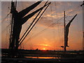
Maldon Hythe-Thames Barge
Taken at sunrise
Image: © Nick Robinson
Taken: 15 Aug 2003
0.06 miles
2
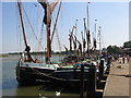
Barges Moored after the Barge Race
Most popular site for visitors to Maldon Quayside
Image: © Bob Marshall
Taken: 18 Aug 2005
0.06 miles
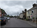
10
Looking from Mill Road into St Mary's Lane
Image: © Basher Eyre
Taken: 19 Jul 2020
0.17 miles