IMAGES TAKEN NEAR TO
Princes Road, MALDON, CM9 5DF
Introduction
This page details the photographs taken nearby to Princes Road, CM9 5DF by members of the Geograph project.
The Geograph project started in 2005 with the aim of publishing, organising and preserving representative images for every square kilometre of Great Britain, Ireland and the Isle of Man.

There are currently over 7.5m images from over14,400 individuals and you can help contribute to the project by visiting https://www.geograph.org.uk
Image Map
Images are licensed for reuse under creativecommons.org/licenses/by-sa/2.0
Notes
- Clicking on the map will re-center to the selected point.
- The higher the marker number, the further away the image location is from the centre of the postcode.
Image Listing (214 Images Found)
Images are licensed for reuse under creativecommons.org/licenses/by-sa/2.0
Image
Details
Distance

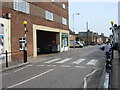
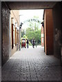
3
Looking from High Street into Dolphin Cut
Image: © Basher Eyre
Taken: 19 Jul 2020
0.13 miles

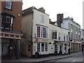
5
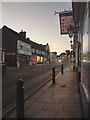
Maldon High Street at dusk
Seen from outside the 'Rose and Crown' on a Monday evening in late October.
Image: © Stefan Czapski
Taken: 27 Oct 2014
0.13 miles
6
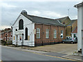
Salvation Army, Maldon
Originally a Primitive Methodist chapel, with the car park a coal yard.
Image: © Robin Webster
Taken: 4 Mar 2014
0.13 miles
8
Continental Coffee Co and The Kings Head Centre
Image: © Oxyman
Taken: 3 May 2008
0.13 miles
9
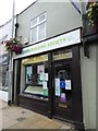
Yorkshire Building Society, High Street
Image: © Basher Eyre
Taken: 19 Jul 2020
0.13 miles