IMAGES TAKEN NEAR TO
High Street, MALDON, CM9 5BF
Introduction
This page details the photographs taken nearby to High Street, CM9 5BF by members of the Geograph project.
The Geograph project started in 2005 with the aim of publishing, organising and preserving representative images for every square kilometre of Great Britain, Ireland and the Isle of Man.

There are currently over 7.5m images from over14,400 individuals and you can help contribute to the project by visiting https://www.geograph.org.uk
Image Map (Loading...)


Getting Data...Please wait
Leaflet Map data © OpenStreetMap
Images are licensed for reuse under creativecommons.org/licenses/by-sa/2.0
Notes
- Clicking on the map will re-center to the selected point.
- The higher the marker number, the further away the image location is from the centre of the postcode.
Image Listing (341 Images Found)
Images are licensed for reuse under creativecommons.org/licenses/by-sa/2.0
Image
Details
Distance
2
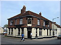
The Warwick at the corner of Victoria Road and the High Street
Image: © Basher Eyre
Taken: 19 Jul 2020
0.01 miles
4

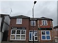
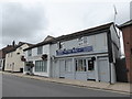
House of Delights Restaurant, High Street
Image: © Basher Eyre
Taken: 19 Jul 2020
0.02 miles
5
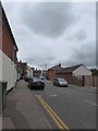
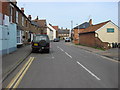
Looking from High Street into Victoria Road
Image: © Basher Eyre
Taken: 19 Jul 2020
0.02 miles
6
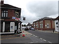
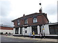
Looking from Victoria Road onto the High Street
Image: © Basher Eyre
Taken: 19 Jul 2020
0.02 miles
7
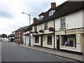
Italian Restaurant, High Street, Maldon
Image: © Roger Cornfoot
Taken: 15 Jun 2011
0.03 miles