IMAGES TAKEN NEAR TO
High Street, CM9 5AJ
Introduction
This page details the photographs taken nearby to High Street, CM9 5AJ by members of the Geograph project.
The Geograph project started in 2005 with the aim of publishing, organising and preserving representative images for every square kilometre of Great Britain, Ireland and the Isle of Man.

There are currently over 7.5m images from over14,400 individuals and you can help contribute to the project by visiting https://www.geograph.org.uk
Image Map
Images are licensed for reuse under creativecommons.org/licenses/by-sa/2.0
Notes
- Clicking on the map will re-center to the selected point.
- The higher the marker number, the further away the image location is from the centre of the postcode.
Image Listing (255 Images Found)
Images are licensed for reuse under creativecommons.org/licenses/by-sa/2.0
Image
Details
Distance
1
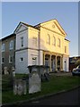
Maldon United Reformed Church, Market Hill
Most Non-Conformist chapels are quite humble buildings, but you could hardly say that of this one. What is more, it occupies rather a fine site - set well back from the street, high on the hill and looking out over the rooftops on the other side of the Chelmer. Part of the graveyard, steeply sloping, is overgrown - and slightly creepy. There are 19th century tomb-chests and obelisks here which are grander than you might expect in a small Essex port - there must have been some 'substantial citizens' among the Non-Conformist congregation.
In my very out-of-date copy of the Essex Pevsner ('The Buildings of England: Essex') this building is listed as a Congregational church.
Image: © Stefan Czapski
Taken: 27 Oct 2014
0.01 miles
2
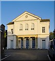
Maldon United Reformed Church, Market Hill (2)
Formerly the Congregational church. According to the listing, in its present form it dates from about 1860, but stands on the site of an earlier chapel: http://www.britishlistedbuildings.co.uk/en-464933-united-reformed-church-maldon-essex
To the north (left in this picture) the ground drops away quite steeply towards the river. The slope must be hard to mow, and in places the churchyard is a picturesque tangle.
Image: © Stefan Czapski
Taken: 27 Oct 2014
0.01 miles
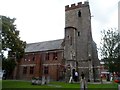
3
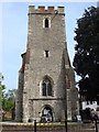
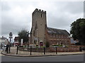
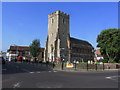
Tower, St. Peter's Church, Maldon
In the seventeenth century Thomas Plume started the Plume Library to house over 7,000 books printed between 1470 and his death in 1704; the collection has been added to at various times since 1704. The Plume Library is to be found at St. Peter's Church. Only the original Tower survives, the rest of the building having been rebuilt by Thomas Plume to house his library (on the first floor) and Maldon Grammar School (on the ground floor)
Source http://www.thomasplumeslibrary.co.uk/about-us/
Image: © Oxyman
Taken: 3 May 2008
0.01 miles
4
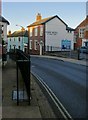
Market Hill, Maldon (1)
The upper end of the street, seen at about 3.45 on an afternoon in late October.
The railings are necessary here, because the narrow pavement rises substantially above the level of the roadway.
Image: © Stefan Czapski
Taken: 27 Oct 2014
0.03 miles
5
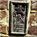
Flush Bracket OSBM 1083S Maldon Market Hill
Flush Bracket OSBM 1083S Maldon Market Hill W face.
Image: © Cud05
Taken: 2 Aug 2018
0.03 miles
7

Tower, former Church of St Peter, Maldon
Grade I listed : description at this https://historicengland.org.uk/listing/the-list/list-entry/1256632. Home to the Plume Library. A full account of the building may be found at this http://www.thomasplumeslibrary.co.uk/history/the-building/.
Image: © Jim Osley
Taken: 25 May 2017
0.03 miles
8
The Plume Building, Maldon
The tower was originally part of St Peter's church. The rest of the church collapsed in 1655. The tower became part of the Grammar school. It now houses a collection of C17 books bequeathed by Dr Thomas Plume (1630-1704).
Image: © Bikeboy
Taken: 13 Sep 2014
0.03 miles