IMAGES TAKEN NEAR TO
Lawling Avenue, MALDON, CM9 4YD
Introduction
This page details the photographs taken nearby to Lawling Avenue, CM9 4YD by members of the Geograph project.
The Geograph project started in 2005 with the aim of publishing, organising and preserving representative images for every square kilometre of Great Britain, Ireland and the Isle of Man.

There are currently over 7.5m images from over14,400 individuals and you can help contribute to the project by visiting https://www.geograph.org.uk
Image Map
Images are licensed for reuse under creativecommons.org/licenses/by-sa/2.0
Notes
- Clicking on the map will re-center to the selected point.
- The higher the marker number, the further away the image location is from the centre of the postcode.
Image Listing (12 Images Found)
Images are licensed for reuse under creativecommons.org/licenses/by-sa/2.0
Image
Details
Distance
1
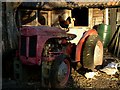
Ferguson & Friend
This old Ferguson is a feature of the farmyard of Jacob’s Farm Shop. Image is a vestige of Haybridge’s agricultural past. It is a few acres of greenish oasis surrounded by houses. Much of the produce in the shop is local if not actually produced on the farm. I am fairly convinced the livestock cows, ducks, chickens etc, are more of an attractive advert than a commercial proposition. The place is quaint and honest, long may it keep Tesco at bay!
Image: © Glyn Baker
Taken: 13 Nov 2004
0.16 miles
2
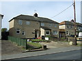
Jacobs Farm
Jacob’s Farm Shop a vestige of Haybridge’s agricultural past. It is a few acres of green surrounded by houses. Much of the produce in the shop is local if not actually grown on the farm.
Image: © Glyn Baker
Taken: 29 Aug 2005
0.16 miles
3
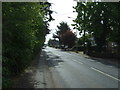
Goldhanger Road (B1026), Heybridge
Looking south east.
Image: © JThomas
Taken: 27 Apr 2017
0.18 miles
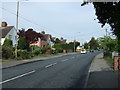
4
Goldhanger Road (B1026), Heybridge
Looking north west.
Image: © JThomas
Taken: 27 Apr 2017
0.19 miles
5
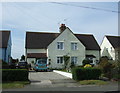
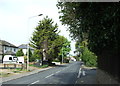
Houses on Goldhanger Road (B1026), Heybridge
Image: © JThomas
Taken: 27 Apr 2017
0.20 miles
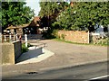
7
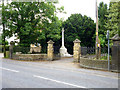
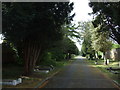
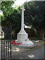
Cemetery gates and war memorial, Heybridge
On Goldhanger Road. The main part of the cemetery is reached via a narrow strip and avenue to beyond the rear of the roadside properties.
Image: © Robin Webster
Taken: 24 Jun 2013
0.20 miles
8
Goldhanger Road (B1026)
Looking north west.
Image: © JThomas
Taken: 27 Apr 2017
0.21 miles