IMAGES TAKEN NEAR TO
Witham Road, MALDON, CM9 4ST
Introduction
This page details the photographs taken nearby to Witham Road, CM9 4ST by members of the Geograph project.
The Geograph project started in 2005 with the aim of publishing, organising and preserving representative images for every square kilometre of Great Britain, Ireland and the Isle of Man.

There are currently over 7.5m images from over14,400 individuals and you can help contribute to the project by visiting https://www.geograph.org.uk
Image Map
Images are licensed for reuse under creativecommons.org/licenses/by-sa/2.0
Notes
- Clicking on the map will re-center to the selected point.
- The higher the marker number, the further away the image location is from the centre of the postcode.
Image Listing (160 Images Found)
Images are licensed for reuse under creativecommons.org/licenses/by-sa/2.0
Image
Details
Distance
1
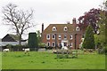
Langford Hall
This picture was taken from the churchyard of Image
Image: © Glyn Baker
Taken: 5 May 2010
0.05 miles
2
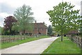
Path to Langford Hall
The footpath approaches Image
Image: © Glyn Baker
Taken: 5 May 2010
0.05 miles
3
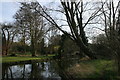
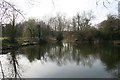
The River Blackwater at Langford
The river upstream of the weir.
Image: © Paul Franks
Taken: 25 Mar 2012
0.08 miles
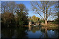
6
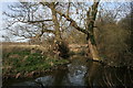
Sidestream of the Blackwater
A short sidestream which leaves the main river above the weir and rejoins it below the weirpool.
Image: © Paul Franks
Taken: 25 Mar 2012
0.12 miles