IMAGES TAKEN NEAR TO
Basin Road, MALDON, CM9 4RN
Introduction
This page details the photographs taken nearby to Basin Road, CM9 4RN by members of the Geograph project.
The Geograph project started in 2005 with the aim of publishing, organising and preserving representative images for every square kilometre of Great Britain, Ireland and the Isle of Man.

There are currently over 7.5m images from over14,400 individuals and you can help contribute to the project by visiting https://www.geograph.org.uk
Image Map (Loading...)


Getting Data...Please wait
Leaflet Map data © OpenStreetMap
Images are licensed for reuse under creativecommons.org/licenses/by-sa/2.0
Notes
- Clicking on the map will re-center to the selected point.
- The higher the marker number, the further away the image location is from the centre of the postcode.
Image Listing (88 Images Found)
Images are licensed for reuse under creativecommons.org/licenses/by-sa/2.0
Image
Details
Distance
1
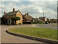
Houses along Basin Road
This junction is where The Colliers, on the left, meets Basin Road.
Image: © Robert Edwards
Taken: 4 Jun 2008
0.06 miles
3
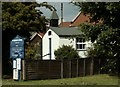
St George's Church, Heybridge Basin, Essex
Image: © Peter Stack
Taken: 8 Feb 2009
0.11 miles
4
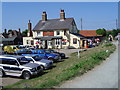
The Jolly Sailor
The Jolly Sailor PH Heybridge Basin Essex
Image: © Stan Wray
Taken: 16 Jul 2005
0.11 miles
5
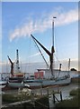
Sailing barge 'Xylonite' at Heybridge Basin
On a tidal berth north of Heybridge Lock, and sitting on mud at low tide.
Image: © Stefan Czapski
Taken: 27 Oct 2015
0.11 miles
7
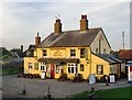
The 'Jolly Sailor', Heybridge Basin
One of two pubs that stand within a few yards of the seawall on the north side of Heybridge sea lock. Photo taken from the seawall, late on an October afternoon.
Image: © Stefan Czapski
Taken: 27 Oct 2015
0.11 miles
8
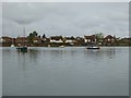
Coastal bungalows at Heybridge
Seen from the Blackwater estuary.
Image: © Oliver Dixon
Taken: 22 Apr 2017
0.12 miles
9

Old Boundary Marker by the sea wall, Basin Road, Heybridge parish
Estate Boundary Marker - Canal by the UC road, in parish of Heybridge (Maldon District), Chelmer and Blackwater Navigation, set in ground on sea wall path at top of ramp immediately South East of Jolly Sailor PH, Basin Road.
Inscription reads:-
C.B.
N.Co.
Surveyed
Milestone Society National ID: EX_CBN02em
Image: © Milestone Society
Taken: Unknown
0.12 miles
10
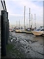
Mud-berths by the Tiptree Tea Room, Heybridge Basin
An assortment of pleasure craft berthed on tidal mud just downstream from the entrance to Heybridge sea lock.
Image: © Stefan Czapski
Taken: 27 Oct 2015
0.12 miles