IMAGES TAKEN NEAR TO
Harold Rise, MALDON, CM9 4QW
Introduction
This page details the photographs taken nearby to Harold Rise, CM9 4QW by members of the Geograph project.
The Geograph project started in 2005 with the aim of publishing, organising and preserving representative images for every square kilometre of Great Britain, Ireland and the Isle of Man.

There are currently over 7.5m images from over14,400 individuals and you can help contribute to the project by visiting https://www.geograph.org.uk
Image Map (Loading...)


Getting Data...Please wait
Leaflet Map data © OpenStreetMap
Images are licensed for reuse under creativecommons.org/licenses/by-sa/2.0
Notes
- Clicking on the map will re-center to the selected point.
- The higher the marker number, the further away the image location is from the centre of the postcode.
Image Listing (23 Images Found)
Images are licensed for reuse under creativecommons.org/licenses/by-sa/2.0
Image
Details
Distance
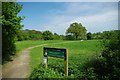
1
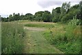
Oak Tree Meadow
This nature reserve was formerly known as Image http://www.wildessex.net/sites/Causeway%20Meadow.htm
Image: © Glyn Baker
Taken: 24 Jun 2017
0.13 miles
2
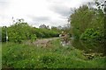
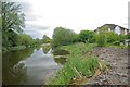
Blackwater & Chelmer Navigation
Here the canal cuts through Heybridge
Image: © Glyn Baker
Taken: 5 May 2010
0.14 miles
3
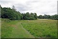
Causeway Meadow
The Causeway Meadow http://www.wildessex.net/sites/Causeway%20Meadow.htm has now been renamed Image
Image: © Glyn Baker
Taken: 24 Jun 2017
0.16 miles
4
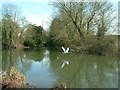
Swan in flight
A swan flying along the Chelmer and Blackwater Navigation.
Image: © Robin Lucas
Taken: 5 Mar 2015
0.16 miles
5
Heybridge Cut
The Blackwater & Chelmer navigation with newly built housing on its banks.
Image: © Glyn Baker
Taken: 5 May 2010
0.17 miles
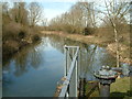
7
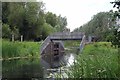
Maldon Bypass Gate
This gate enables the Langford cut to be isolated from the rest of the navigation.
Image: © Glyn Baker
Taken: 24 Jun 2017
0.20 miles
8
Maldon Bypass Gates
This is a flood defence gate on the Langford cut of the Chelmer and Blackwater navigation. Viewed from beneath the A414 road bridge.
Image: © Robin Lucas
Taken: 5 Mar 2015
0.21 miles
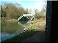
9
Chelmer and Blackwater Navigation
Part of the Langford cut viewed from the flood defence gate.
Image: © Robin Lucas
Taken: 5 Mar 2015
0.21 miles
10
Oak Tree Meadow
This area is rich in Iron Age and Roman archaeology as well as the open space there is an extensive playground see http://www.maldon.gov.uk/Leisure/ParksAndOpenSpaces/Parks/Oak+Tree+Meadow.htm for more info
Image: © Glyn Baker
Taken: 5 May 2010
0.21 miles