IMAGES TAKEN NEAR TO
The Street, MALDON, CM9 4NB
Introduction
This page details the photographs taken nearby to The Street, CM9 4NB by members of the Geograph project.
The Geograph project started in 2005 with the aim of publishing, organising and preserving representative images for every square kilometre of Great Britain, Ireland and the Isle of Man.

There are currently over 7.5m images from over14,400 individuals and you can help contribute to the project by visiting https://www.geograph.org.uk
Image Map (Loading...)


Getting Data...Please wait
Leaflet Map data © OpenStreetMap
Images are licensed for reuse under creativecommons.org/licenses/by-sa/2.0
Notes
- Clicking on the map will re-center to the selected point.
- The higher the marker number, the further away the image location is from the centre of the postcode.
Image Listing (42 Images Found)
Images are licensed for reuse under creativecommons.org/licenses/by-sa/2.0
Image
Details
Distance
1
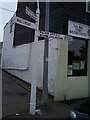
Direction Sign ? Signpost on the B1022 the Street in Heybridge
Located on the southwest side of the junction of the B1022 The Street and Hall Road in Heybridge parish. 3 arms, 1 broken, and gas lamp finial, now lost. A Maldon Iron Works post that was originally fitted with a gas lamp. When photographed one arm was broken - still the case in 2020 - and the pillar was severely cracked at the top.
Milestone Society National ID: EX_TL8507
Image: © John V Nicholls
Taken: Unknown
0.02 miles
2
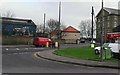
Junction at Heybridge
Where The Street meets Hall Road
Image: © Clint Mann
Taken: 11 Dec 2001
0.04 miles
3
Entrance to St Andrew's Church, Heybridge
Viewed from The Street
Image: © Clint Mann
Taken: 11 Dec 2001
0.05 miles
4
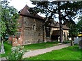
St Andrew's church, Heybridge
C12 church with C15 extension to the east.
Image: © Bikeboy
Taken: 13 Sep 2014
0.05 miles
5
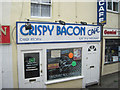
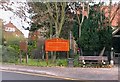
Crispy Bacon cafe in Heybridge Street
A few yards south east of the roundabout
Image: © John Firth
Taken: 14 Sep 2010
0.05 miles
6
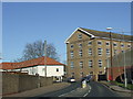
The Street, Heybridge
The building in the centre of the image is a former factory, now converted into offices.
Image: © Malc McDonald
Taken: 20 Apr 2013
0.05 miles
7
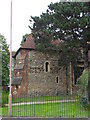
St Andrew's Church, Heybridge
The church building was completed in the 12th century. Somewhere around 1450 flooding caused the tower to collapse and the 'ruins' were restored to more or less the present form later in the 15th century: http://www.standrewandgeorge.co.uk/
Image: © Chris Holifield
Taken: 30 Aug 2015
0.05 miles
9
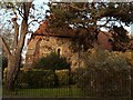
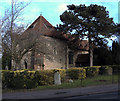
St. Andrew's church, Heybridge, Essex
The church dates back to the Norman period and there are traces of re-used Roman bricks in its fabric. There is evidence that the church once had a west tower but it is just the lower section that now survives, with an added pyramid roof, and this section of the tower now forms part of the nave.
Image: © Robert Edwards
Taken: 27 Nov 2006
0.06 miles
10
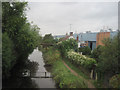
Chelmer and Blackwater Navigation at Colchester road bridge
Image: © John Firth
Taken: 14 Sep 2010
0.07 miles