IMAGES TAKEN NEAR TO
CM9 4HB
Introduction
This page details the photographs taken nearby to CM9 4HB by members of the Geograph project.
The Geograph project started in 2005 with the aim of publishing, organising and preserving representative images for every square kilometre of Great Britain, Ireland and the Isle of Man.

There are currently over 7.5m images from over14,400 individuals and you can help contribute to the project by visiting https://www.geograph.org.uk
Image Map
Images are licensed for reuse under creativecommons.org/licenses/by-sa/2.0
Notes
- Clicking on the map will re-center to the selected point.
- The higher the marker number, the further away the image location is from the centre of the postcode.
Image Listing (39 Images Found)
Images are licensed for reuse under creativecommons.org/licenses/by-sa/2.0
Image
Details
Distance
3
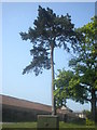
Scots Pine tree
This is a Scots Pine (Pinus sylvestris) standing around 20 metres tall.
Image: © Lewis Potter
Taken: 25 Apr 2011
0.05 miles
4

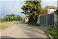
Leading to towpath beside the Chelme and Blackwater Canal
Image: © Chris Morgan
Taken: 6 Aug 2021
0.05 miles
5
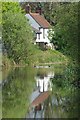
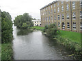
Navigation Cottage
Navigation Cottage reflected in the waters of the Chelmer & Blackwater Navigation. http://www.cbn.co.uk/
Image: © Glyn Baker
Taken: 5 May 2010
0.08 miles
6
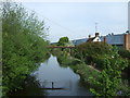
Chelmer and Blackwater Navigation at Heybridge
Image: © John Firth
Taken: 14 Sep 2010
0.08 miles
7
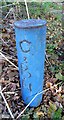
Old Boundary Marker by the B1022, Wave Bridge, Heybridge parish
Estate Boundary Marker - Canal, by the B1022, in parish of Heybridge (Maldon District); Chelmer and Blackwater Navigation, Southeast of Wave Bridge.
Inscription reads vertically:-
C
&
B
N
Surveyed
Milestone Society National ID: EX_CBN01em
Image: © Milestone Society
Taken: Unknown
0.09 miles
8
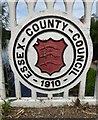
Old Bridge Marker by the B1022, Goldhanger Bridge, Heybridge parish
Bridge Marker by the B1022, in parish of Heybridge (Maldon District), Goldhanger Bridge - North side - Chelmer and Blackwater Navigation. Matching plaques on both North and South sides of the bridge, cast into the parapets.
Inscription reads:-
ESSEX - COUNTY - COUNCIL
{coat of arms}
- 1910 -
Essex HER - Goldhanger Bridge.
SMR Number: 40183 https://www.heritagegateway.org.uk/Gateway/Results_Single.aspx?uid=MEX1033951&resourceID=1001
Surveyed
Milestone Society National ID: EX_HEYB01br
Image: © M Bardell
Taken: 16 Aug 2017
0.09 miles
9
Chelmer and Blackwater Navigation
View north west from Colchester Road Bridge.
Image: © JThomas
Taken: 27 Apr 2017
0.10 miles
10
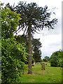
Monkey puzzle tree, Heybridge cemetery
In the extreme north-west corner of the cemetery.
Image: © Robin Webster
Taken: 24 Jun 2013
0.10 miles