IMAGES TAKEN NEAR TO
Spickets Drive, MALDON, CM9 4DH
Introduction
This page details the photographs taken nearby to Spickets Drive, CM9 4DH by members of the Geograph project.
The Geograph project started in 2005 with the aim of publishing, organising and preserving representative images for every square kilometre of Great Britain, Ireland and the Isle of Man.

There are currently over 7.5m images from over14,400 individuals and you can help contribute to the project by visiting https://www.geograph.org.uk
Image Map (Loading...)


Getting Data...Please wait
Leaflet Map data © OpenStreetMap
Images are licensed for reuse under creativecommons.org/licenses/by-sa/2.0
Notes
- Clicking on the map will re-center to the selected point.
- The higher the marker number, the further away the image location is from the centre of the postcode.
Image Listing (3 Images Found)
Images are licensed for reuse under creativecommons.org/licenses/by-sa/2.0
Image
Details
Distance
1
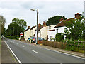
Cottages, Broad Street Green Road
These are either at the southern end of the mainly linear settlement along this road called Broad Street Green, or alternatively, at the northern fringe of Heybridge.
Image: © Robin Webster
Taken: 24 Jun 2013
0.04 miles
2
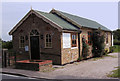
Christian Outreach Centre, Heybridge, Essex
Image: © Peter Stack
Taken: 29 May 2009
0.08 miles
3
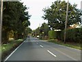
Broad Street Green Road
This road is the B.1022 between Heybridge and Great Totham.
Image: © Robert Edwards
Taken: 20 Oct 2006
0.20 miles