IMAGES TAKEN NEAR TO
Oyster Mews, MALDON, CM9 4DA
Introduction
This page details the photographs taken nearby to Oyster Mews, CM9 4DA by members of the Geograph project.
The Geograph project started in 2005 with the aim of publishing, organising and preserving representative images for every square kilometre of Great Britain, Ireland and the Isle of Man.

There are currently over 7.5m images from over14,400 individuals and you can help contribute to the project by visiting https://www.geograph.org.uk
Image Map
Images are licensed for reuse under creativecommons.org/licenses/by-sa/2.0
Notes
- Clicking on the map will re-center to the selected point.
- The higher the marker number, the further away the image location is from the centre of the postcode.
Image Listing (7 Images Found)
Images are licensed for reuse under creativecommons.org/licenses/by-sa/2.0
Image
Details
Distance
2
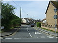
Crescent Road, Heybridge, Maldon
Looking south west from Holloway Road.
Image: © JThomas
Taken: 27 Apr 2017
0.15 miles
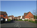
3
Modern housing near Heybridge
The road is called Doubleday Drive.
Image: © Robert Edwards
Taken: 7 May 2008
0.15 miles
4
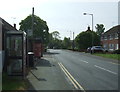
Bus stop and telephone box on Holloway Road
Image: © JThomas
Taken: 27 Apr 2017
0.18 miles
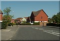
5
Doubleday Drive, Heybridge
Doubleday Drive is part of a new housing development in Heybridge, Essex.
Image: © Malc McDonald
Taken: 20 Apr 2013
0.19 miles
6
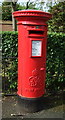
George VI postbox on Holloway Road, Heybridge
Postbox No. CM9 223.
See Image] for context.
Image: © JThomas
Taken: 27 Apr 2017
0.19 miles
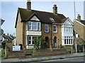
7
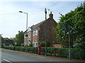
House on Holloway Road, Heybridge
Showing position of Postbox No. CM9 223.
See Image] for postbox.
Image: © JThomas
Taken: 27 Apr 2017
0.19 miles