IMAGES TAKEN NEAR TO
St. Marys Road, WITHAM, CM8 3PE
Introduction
This page details the photographs taken nearby to St. Marys Road, CM8 3PE by members of the Geograph project.
The Geograph project started in 2005 with the aim of publishing, organising and preserving representative images for every square kilometre of Great Britain, Ireland and the Isle of Man.

There are currently over 7.5m images from over14,400 individuals and you can help contribute to the project by visiting https://www.geograph.org.uk
Image Map
Images are licensed for reuse under creativecommons.org/licenses/by-sa/2.0
Notes
- Clicking on the map will re-center to the selected point.
- The higher the marker number, the further away the image location is from the centre of the postcode.
Image Listing (75 Images Found)
Images are licensed for reuse under creativecommons.org/licenses/by-sa/2.0
Image
Details
Distance
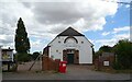
1
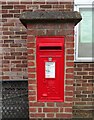
Elizabeth II postbox on Church Road, Rivenhall
Postbox No. CM8 466.
Image: © JThomas
Taken: 24 Aug 2022
0.05 miles
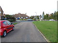
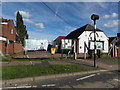
3
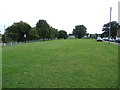
Rivenhall Village Green
Off Church Road & Beech Road
Image: © Geographer
Taken: 10 Oct 2019
0.05 miles
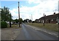
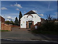
5
Beech Road, Rivenhall
At the junction with St. Marys Road
Road No.U4463
Image: © Geographer
Taken: 10 Oct 2019
0.06 miles
7
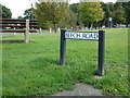
Beech Road sign
On Beech Road at the junction with St. Marys Road
Road No.U4463
Image: © Geographer
Taken: 10 Oct 2019
0.06 miles
10
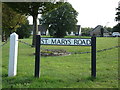
St. Marys Road sign
On St. Marys Road at the junction with Church Road
Road No.U4462
Image: © Geographer
Taken: 10 Oct 2019
0.06 miles