IMAGES TAKEN NEAR TO
Birch Close, WITHAM, CM8 2SL
Introduction
This page details the photographs taken nearby to Birch Close, CM8 2SL by members of the Geograph project.
The Geograph project started in 2005 with the aim of publishing, organising and preserving representative images for every square kilometre of Great Britain, Ireland and the Isle of Man.

There are currently over 7.5m images from over14,400 individuals and you can help contribute to the project by visiting https://www.geograph.org.uk
Image Map (Loading...)


Getting Data...Please wait
Leaflet Map data © OpenStreetMap
Images are licensed for reuse under creativecommons.org/licenses/by-sa/2.0
Notes
- Clicking on the map will re-center to the selected point.
- The higher the marker number, the further away the image location is from the centre of the postcode.
Image Listing (17 Images Found)
Images are licensed for reuse under creativecommons.org/licenses/by-sa/2.0
Image
Details
Distance
1
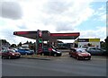
Service station on Braintree Road, Witham
Petrol 162.9p.
Diesel 182.9p.
Image: © JThomas
Taken: 24 Aug 2022
0.10 miles
2
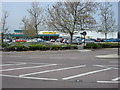
Morrisons supermarket, Braintree Road, Witham
Image: © Oxyman
Taken: 3 May 2008
0.11 miles
3
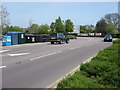
Unnamed road leading to Morrisons supermarket
Image: © Oxyman
Taken: 3 May 2008
0.12 miles
4
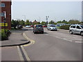
Unnamed road leading to Morrisons supermarket
Image: © Oxyman
Taken: 3 May 2008
0.14 miles
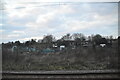
7
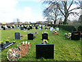
Witham cemetery - newer part
The original plot is to the right of the hedge. This area seems to be taken over from a recreation ground off to the left.
Image: © Robin Webster
Taken: 1 Mar 2015
0.17 miles
8

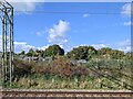
Branch line at Witham
Viewed from main line between Witham and Colchester. The branch line leads to Braintree.
Image: © Clint Mann
Taken: 4 May 2016
0.19 miles
9

Rickstones Evangelical Church
On Rickstones Road.
Image: © JThomas
Taken: 24 Aug 2022
0.20 miles
