IMAGES TAKEN NEAR TO
Blake Road, WITHAM, CM8 2QB
Introduction
This page details the photographs taken nearby to Blake Road, CM8 2QB by members of the Geograph project.
The Geograph project started in 2005 with the aim of publishing, organising and preserving representative images for every square kilometre of Great Britain, Ireland and the Isle of Man.

There are currently over 7.5m images from over14,400 individuals and you can help contribute to the project by visiting https://www.geograph.org.uk
Image Map (Loading...)


Getting Data...Please wait
Leaflet Map data © OpenStreetMap
Images are licensed for reuse under creativecommons.org/licenses/by-sa/2.0
Notes
- Clicking on the map will re-center to the selected point.
- The higher the marker number, the further away the image location is from the centre of the postcode.
Image Listing (10 Images Found)
Images are licensed for reuse under creativecommons.org/licenses/by-sa/2.0
Image
Details
Distance
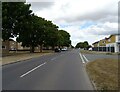

4

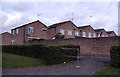
Suburban Witham
Witham has grown a great deal since World War II.
Image: © Robin Webster
Taken: 1 Mar 2015
0.20 miles
6
B1018 Cressing Road. Witham
Near The Cherry Tree Public House
Image: © Geographer
Taken: 5 Oct 2019
0.23 miles
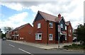
7
The Courts, Housing Estate, Witham, Essex
Image: © Peter Stack
Taken: 4 Sep 2010
0.23 miles
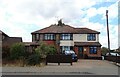
8
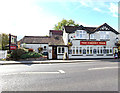
The Cherry Tree Public House, Witham
Off the B1018 Cressing Road
Image: © Geographer
Taken: 5 Oct 2019
0.24 miles
9

The Cherry Tree on Cressing Road, Witham
Image: © David Howard
Taken: 4 Apr 2017
0.24 miles
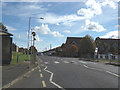
10

Cherry Tree Pub, Witham, Essex
Junction of Cressing Road and Upper Acres.
Image: © Peter Stack
Taken: 4 Sep 2010
0.24 miles