IMAGES TAKEN NEAR TO
Butcher Row, WITHAM, CM8 1YR
Introduction
This page details the photographs taken nearby to Butcher Row, CM8 1YR by members of the Geograph project.
The Geograph project started in 2005 with the aim of publishing, organising and preserving representative images for every square kilometre of Great Britain, Ireland and the Isle of Man.

There are currently over 7.5m images from over14,400 individuals and you can help contribute to the project by visiting https://www.geograph.org.uk
Image Map (Loading...)


Getting Data...Please wait
Leaflet Map data © OpenStreetMap
Images are licensed for reuse under creativecommons.org/licenses/by-sa/2.0
Notes
- Clicking on the map will re-center to the selected point.
- The higher the marker number, the further away the image location is from the centre of the postcode.
Image Listing (8 Images Found)
Images are licensed for reuse under creativecommons.org/licenses/by-sa/2.0
Image
Details
Distance
1
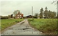
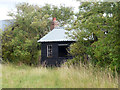
Lodge Farm
This is the view from the B.1389
Image: © Robert Edwards
Taken: 27 Nov 2006
0.08 miles
3
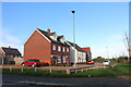
Hatfield Road, Witham
Robinsons Pallet Services is opposite.
Image: © David Howard
Taken: 27 Oct 2024
0.11 miles
4
Relic of a former enterprise
At the site mapped as Mayfield Nursery, which appears to have seen better days.
Image: © Robin Webster
Taken: 14 Aug 2015
0.20 miles
5
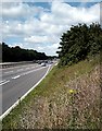
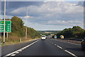
A12, Witham Bypass
Sunday morning traffic bound for the East Coast.
Image: © John Myers
Taken: 17 Jun 2007
0.21 miles
7
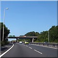
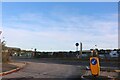
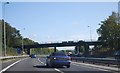
B1389 Hatfield Road bridge over A12
South-west of Witham, there is a junction between the A12 and B1389, only accessible for traffic joining the southbound A12 carriageway or leaving the northbound A12 carriageway. The bridge carries the former traffic
Image: © David Smith
Taken: 21 Jun 2014
0.23 miles