IMAGES TAKEN NEAR TO
Reid Road, WITHAM, CM8 1XU
Introduction
This page details the photographs taken nearby to Reid Road, CM8 1XU by members of the Geograph project.
The Geograph project started in 2005 with the aim of publishing, organising and preserving representative images for every square kilometre of Great Britain, Ireland and the Isle of Man.

There are currently over 7.5m images from over14,400 individuals and you can help contribute to the project by visiting https://www.geograph.org.uk
Image Map (Loading...)


Getting Data...Please wait
Leaflet Map data © OpenStreetMap
Images are licensed for reuse under creativecommons.org/licenses/by-sa/2.0
Notes
- Clicking on the map will re-center to the selected point.
- The higher the marker number, the further away the image location is from the centre of the postcode.
Image Listing (6 Images Found)
Images are licensed for reuse under creativecommons.org/licenses/by-sa/2.0
Image
Details
Distance
1
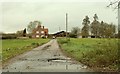
Lodge Farm
This is the view from the B.1389
Image: © Robert Edwards
Taken: 27 Nov 2006
0.13 miles
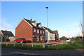
2
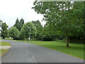
Witham Lodge (road)
A branched road on a housing estate built on the grounds of Witham Lodge, a large house which was demolished.
Image: © Robin Webster
Taken: 21 Jun 2015
0.17 miles
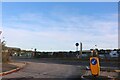
3
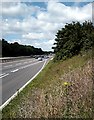
A12, Witham Bypass
Sunday morning traffic bound for the East Coast.
Image: © John Myers
Taken: 17 Jun 2007
0.18 miles
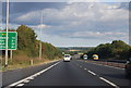
6
Hatfield Road, Witham
Robinsons Pallet Services is opposite.
Image: © David Howard
Taken: 27 Oct 2024
0.23 miles