IMAGES TAKEN NEAR TO
Carraways, WITHAM, CM8 1XT
Introduction
This page details the photographs taken nearby to Carraways, CM8 1XT by members of the Geograph project.
The Geograph project started in 2005 with the aim of publishing, organising and preserving representative images for every square kilometre of Great Britain, Ireland and the Isle of Man.

There are currently over 7.5m images from over14,400 individuals and you can help contribute to the project by visiting https://www.geograph.org.uk
Image Map
Images are licensed for reuse under creativecommons.org/licenses/by-sa/2.0
Notes
- Clicking on the map will re-center to the selected point.
- The higher the marker number, the further away the image location is from the centre of the postcode.
Image Listing (15 Images Found)
Images are licensed for reuse under creativecommons.org/licenses/by-sa/2.0
Image
Details
Distance
1
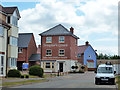
Templar's Green sales information centre
A new development on a rough field between earlier development, as on the extreme left, and the A12, beyond the high sound fence.
Image: © Robin Webster
Taken: 21 Jun 2015
0.06 miles
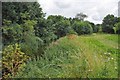
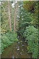
2

The River Brain
East of Saul's Bridge.
Image: © Trevor Harris
Taken: 1 Apr 2012
0.09 miles
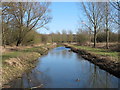
3

The River Brain
Looking upstream from the riverside walk
Image: © Glyn Baker
Taken: 3 Aug 2012
0.10 miles
4

A modern ford, Witham
This route under the Witham bypass (A12) has a high level option, normally dry, and a long ford along the River Brain, presumably for high agricultural vehicles, although no recent use was apparent. It appears to be running at about 0.3 m deep or less here, with the river fairly low. Publicly this is only a footpath.
Image: © Robin Webster
Taken: 21 Jun 2015
0.12 miles
5

Towards Whet Mead
Image: © Glyn Baker
Taken: 3 Aug 2012
0.13 miles
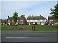
6
Shelly's Meadow
This is private land beside the River Brain however there is a plaque at the gate to say the public are welcome to walk here.
Image: © Glyn Baker
Taken: 3 Aug 2012
0.16 miles
7
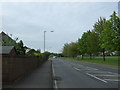
Maldon Road, Witham
Looking south west on the B1018.
Image: © JThomas
Taken: 27 Apr 2017
0.17 miles
9
River Brain
Taken from the bridge on Maldon Road
Image: © Glyn Baker
Taken: 3 Aug 2012
0.18 miles
10
River Brain, Whet Mead Local Nature Reserve, Witham
Compare to Image which has a summer view of the same scene.
Whet Mead Local Nature Reserve is managed by Braintree Council. It is bordered on two sides by the Rivers Blackwater and Brain.
Links
Wild Essex: http://www.wildessex.net/sites/Whet%20Mead.htm
Braintree Council: http://www.braintree.gov.uk/directory_record/2039/whetmead_local_nature_reserve_witham
Image
Image
Image
Image
Image: © Roger Jones
Taken: 1 Mar 2015
0.18 miles