IMAGES TAKEN NEAR TO
King Edward Way, WITHAM, CM8 1PF
Introduction
This page details the photographs taken nearby to King Edward Way, CM8 1PF by members of the Geograph project.
The Geograph project started in 2005 with the aim of publishing, organising and preserving representative images for every square kilometre of Great Britain, Ireland and the Isle of Man.

There are currently over 7.5m images from over14,400 individuals and you can help contribute to the project by visiting https://www.geograph.org.uk
Image Map (Loading...)


Getting Data...Please wait
Leaflet Map data © OpenStreetMap
Images are licensed for reuse under creativecommons.org/licenses/by-sa/2.0
Notes
- Clicking on the map will re-center to the selected point.
- The higher the marker number, the further away the image location is from the centre of the postcode.
Image Listing (8 Images Found)
Images are licensed for reuse under creativecommons.org/licenses/by-sa/2.0
Image
Details
Distance
1
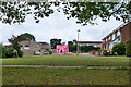
A bouncy castle, Witham
Set up on a bit of green off King Edward Way, was this for a birthday party?
Image: © Robin Webster
Taken: 21 Jun 2015
0.05 miles
4

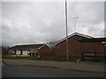
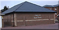
Witham fire station
Witham fire station, Hatfield Road, Witham, Essex
Image: © Kevin Hale
Taken: 4 Jun 2010
0.19 miles
5
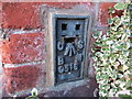
Ordnance Survey Flush Bracket G516
This can be found on the wall of a former hospital - now apartment complex - in Witham.
For more detail see : http://www.bench-marks.org.uk/bm10937
Image: © Peter Wood
Taken: 23 Feb 2015
0.24 miles
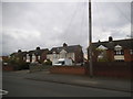
7
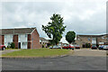
Car park at Allectus Way end of Wulvesford, Witham
Wulvesford is a path serving houses with no normal vehicle access.
Image: © Robin Webster
Taken: 21 Jun 2015
0.25 miles