IMAGES TAKEN NEAR TO
Blunts Hall Road, WITHAM, CM8 1LY
Introduction
This page details the photographs taken nearby to Blunts Hall Road, CM8 1LY by members of the Geograph project.
The Geograph project started in 2005 with the aim of publishing, organising and preserving representative images for every square kilometre of Great Britain, Ireland and the Isle of Man.

There are currently over 7.5m images from over14,400 individuals and you can help contribute to the project by visiting https://www.geograph.org.uk
Image Map (Loading...)


Getting Data...Please wait
Leaflet Map data © OpenStreetMap
Images are licensed for reuse under creativecommons.org/licenses/by-sa/2.0
Notes
- Clicking on the map will re-center to the selected point.
- The higher the marker number, the further away the image location is from the centre of the postcode.
Image Listing (8 Images Found)
Images are licensed for reuse under creativecommons.org/licenses/by-sa/2.0
Image
Details
Distance
1
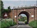
Witham, railway bridge in Blunts Hall Road
Conflicting information for high vehicle drivers, 14'0" on advance sign but 15'0" on the actual arch!
Image: © Tony Wheeler
Taken: 16 May 2000
0.13 miles
3
Blunts Hall Road, Witham, from the railway
Image: © Christopher Hilton
Taken: 25 Apr 2018
0.14 miles
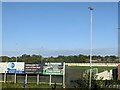
4

Village Glass Stadium, Witham
The home ground of Witham Town FC.
Image: © Stuart Shepherd
Taken: 16 Aug 2016
0.16 miles
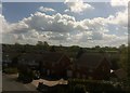
5

Blunts Hall Farm, Witham, Essex
December 2009.
Image: © Peter Stack
Taken: 25 Dec 2009
0.19 miles
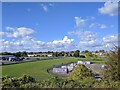
6

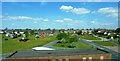
Witham: skateboard park and open space from the railway
On the left, the edge of Witham Town FC's ground.
Image: © Christopher Hilton
Taken: 26 Sep 2018
0.24 miles
8
Sports Ground at Witham
Adjacent to Witham Town Football Club ground (to left) and ASDA (to right). Viewed from railway line, approaching Witham Station.
Image: © Clint Mann
Taken: 4 May 2016
0.25 miles