IMAGES TAKEN NEAR TO
Faulkbourne Road, WITHAM, CM8 1LR
Introduction
This page details the photographs taken nearby to Faulkbourne Road, CM8 1LR by members of the Geograph project.
The Geograph project started in 2005 with the aim of publishing, organising and preserving representative images for every square kilometre of Great Britain, Ireland and the Isle of Man.

There are currently over 7.5m images from over14,400 individuals and you can help contribute to the project by visiting https://www.geograph.org.uk
Image Map
Images are licensed for reuse under creativecommons.org/licenses/by-sa/2.0
Notes
- Clicking on the map will re-center to the selected point.
- The higher the marker number, the further away the image location is from the centre of the postcode.
Image Listing (6 Images Found)
Images are licensed for reuse under creativecommons.org/licenses/by-sa/2.0
Image
Details
Distance
1
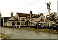
'The Victoria' inn, Powers Hall End, Witham, Essex
Image: © Robert Edwards
Taken: 5 Jul 2006
0.08 miles
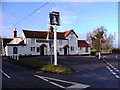
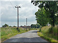
3
Terling Road enters Witham
The sign informs us that Witham is twinned with Waldbröl. Wikipedia tells us that Waldbröl is a town in the southern part of the Oberbergischer Kreis, in North Rhine-Westphalia, Germany.
Image: © Robin Webster
Taken: 21 Jun 2015
0.10 miles
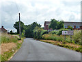
4
Terling Road
Approaching Witham from Terling.
Image: © Robin Webster
Taken: 21 Jun 2015
0.17 miles