IMAGES TAKEN NEAR TO
Mersey Road, WITHAM, CM8 1LJ
Introduction
This page details the photographs taken nearby to Mersey Road, CM8 1LJ by members of the Geograph project.
The Geograph project started in 2005 with the aim of publishing, organising and preserving representative images for every square kilometre of Great Britain, Ireland and the Isle of Man.

There are currently over 7.5m images from over14,400 individuals and you can help contribute to the project by visiting https://www.geograph.org.uk
Image Map
Images are licensed for reuse under creativecommons.org/licenses/by-sa/2.0
Notes
- Clicking on the map will re-center to the selected point.
- The higher the marker number, the further away the image location is from the centre of the postcode.
Image Listing (7 Images Found)
Images are licensed for reuse under creativecommons.org/licenses/by-sa/2.0
Image
Details
Distance
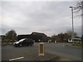
2

Sports Ground at Witham
Adjacent to Witham Town Football Club ground (to left) and ASDA (to right). Viewed from railway line, approaching Witham Station.
Image: © Clint Mann
Taken: 4 May 2016
0.21 miles
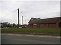
5

Medical Centre, Douglas Grove, Witham, Essex
Image: © Peter Stack
Taken: 1 Sep 2010
0.23 miles
6
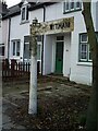
Direction Sign ? Signpost on Powers Hall End, Witham
Located on the north side of the T junction of Powers Hall Lane and Highfields Road in Witham parish. 3 arms, 2 missing, and cone finial.
Milestone Society National ID: EX_TL8115
Image: © John V Nicholls
Taken: Unknown
0.24 miles
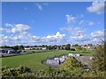
7

Witham: skateboard park and open space from the railway
On the left, the edge of Witham Town FC's ground.
Image: © Christopher Hilton
Taken: 26 Sep 2018
0.25 miles