IMAGES TAKEN NEAR TO
Duncombe Close, WITHAM, CM8 1GR
Introduction
This page details the photographs taken nearby to Duncombe Close, CM8 1GR by members of the Geograph project.
The Geograph project started in 2005 with the aim of publishing, organising and preserving representative images for every square kilometre of Great Britain, Ireland and the Isle of Man.

There are currently over 7.5m images from over14,400 individuals and you can help contribute to the project by visiting https://www.geograph.org.uk
Image Map (Loading...)


Getting Data...Please wait
Leaflet Map data © OpenStreetMap
Images are licensed for reuse under creativecommons.org/licenses/by-sa/2.0
Notes
- Clicking on the map will re-center to the selected point.
- The higher the marker number, the further away the image location is from the centre of the postcode.
Image Listing (4 Images Found)
Images are licensed for reuse under creativecommons.org/licenses/by-sa/2.0
Image
Details
Distance
1
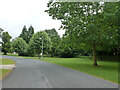
Witham Lodge (road)
A branched road on a housing estate built on the grounds of Witham Lodge, a large house which was demolished.
Image: © Robin Webster
Taken: 21 Jun 2015
0.08 miles
2
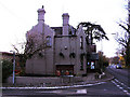
Jack and Jenny PH, Witham, Essex
Junction of Maltings Lane and Hatfield Road.
Image: © Peter Stack
Taken: 28 Nov 2010
0.12 miles
4
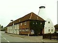
Old Maltings, Witham, Essex
This old building has now been converted into living accommodation. It is now called The Oast House.
Image: © Robert Edwards
Taken: 5 Jul 2006
0.23 miles