IMAGES TAKEN NEAR TO
Vernon Way, BRAINTREE, CM7 9TY
Introduction
This page details the photographs taken nearby to Vernon Way, CM7 9TY by members of the Geograph project.
The Geograph project started in 2005 with the aim of publishing, organising and preserving representative images for every square kilometre of Great Britain, Ireland and the Isle of Man.

There are currently over 7.5m images from over14,400 individuals and you can help contribute to the project by visiting https://www.geograph.org.uk
Image Map
Images are licensed for reuse under creativecommons.org/licenses/by-sa/2.0
Notes
- Clicking on the map will re-center to the selected point.
- The higher the marker number, the further away the image location is from the centre of the postcode.
Image Listing (2 Images Found)
Images are licensed for reuse under creativecommons.org/licenses/by-sa/2.0
Image
Details
Distance
1
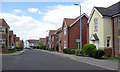
Modern housing, Braintree
Braintree has greatly expanded in recent years, and this is typical of the new housing.
Image: © Robin Webster
Taken: 18 Apr 2007
0.17 miles
2
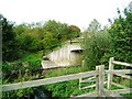
River Blackwater/Bridge under A131 at Braintree
This river takes its course north of Braintree and makes full use of its flood plain both sides of the A131 during heavy rains Oct/Nov most years. This small bridge allows the river to flow under the main road and eastwards on its journey to the sea, emerging at Maldon into the tidal estuary.
Image: © Brenda Howard
Taken: 5 Oct 2005
0.21 miles