IMAGES TAKEN NEAR TO
Doubleday Gardens, BRAINTREE, CM7 9SW
Introduction
This page details the photographs taken nearby to Doubleday Gardens, CM7 9SW by members of the Geograph project.
The Geograph project started in 2005 with the aim of publishing, organising and preserving representative images for every square kilometre of Great Britain, Ireland and the Isle of Man.

There are currently over 7.5m images from over14,400 individuals and you can help contribute to the project by visiting https://www.geograph.org.uk
Image Map (Loading...)


Getting Data...Please wait
Leaflet Map data © OpenStreetMap
Images are licensed for reuse under creativecommons.org/licenses/by-sa/2.0
Notes
- Clicking on the map will re-center to the selected point.
- The higher the marker number, the further away the image location is from the centre of the postcode.
Image Listing (11 Images Found)
Images are licensed for reuse under creativecommons.org/licenses/by-sa/2.0
Image
Details
Distance
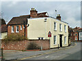
1
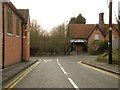
A view from Convent Lane
This is the road junction where Convent Lane meets the B1053.
Image: © Robert Edwards
Taken: 24 Feb 2010
0.14 miles
2

Franciscan Convent Chapel, Broad Road, Bocking, Braintree
The Chapel of the Immaculate Conception, is situated next to the River Blackwater and was built as an extension to Bridge House, which was bought from the Courtauld Family. It was completed in May 1899.
Image: © Brenda Howard
Taken: 2 Oct 2005
0.15 miles
3
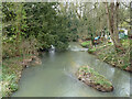
River Blackwater below Bradford Bridge, Bocking
Image: © Robin Webster
Taken: 19 Mar 2013
0.16 miles
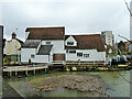
4
Bradfordstreet Mill, Bocking
On the banks of the River Blackwater.
From Brenda Howard's contribution it would appear that this was a working mill - or, at least, used for industrial purposes - up until about 10 years ago. http://www.geograph.org.uk/photo/60598 It has in the meantime become a private residence.
Image: © Stefan Czapski
Taken: 14 Aug 2015
0.18 miles
5
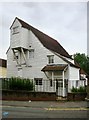
House with pargetting, Convent Hill, Bocking
Close to Bradford Bridge - across the river known downstream as the Blackwater and upstream as the Pant. The property (known as Mill House?) was to let at the time of the photograph. Just visible over the cornice is the white weather-boarded gable of the big mill next door.
What isn't apparent in this view is that - behind the high cornice - the house is gambrel-roofed. The Georgian façade must have been added to an older house, which could well be timber-framed. The gable-end of the building can be seen in: Image
Image: © Stefan Czapski
Taken: 14 Aug 2015
0.18 miles
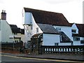
6
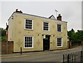
Bradford Mill House, Bocking
A grade II listed building, 18th century.
Image: © Robin Webster
Taken: 19 Mar 2013
0.18 miles
7
Bocking formerly Bradford Mill
An 18th century grade II*(star) listed building on the River Blackwater.
Image: © Robin Webster
Taken: 19 Mar 2013
0.19 miles
8

View south-west from Bradford Bridge, Bocking
The cream-painted building (right of centre) is the subject of Image In that picture, the street-front looks Georgian (and quite urban) but it's clear from the end elevation that the corniced façade was added to an earlier gambrel-roofed building. There also appears to be a timber-framed range (with jettied first-floor) - running back at right-angles to the road.
I'm in a bit of a quandary as to the street name. The OS calls this stretch Convent Hill, but it also seems to be known locally as Bradford Street.
The bridge crosses the River Blackwater, or Pant, as it is known in its upper reaches - information gleaned from Brenda Howard's contributions: http://www.geograph.org.uk/photo/60598 http://www.geograph.org.uk/photo/60611
Image: © Stefan Czapski
Taken: 14 Aug 2015
0.20 miles
9
Bocking Bradfordstreet Mill, Bocking, Braintree
Most recently used for making pellets and cubes for animal feed but no longer water powered. It is at this point that the road changes from Bradford Street, to Broad Road, and the river changes its name from Blackwater to Pant.
Image: © Brenda Howard
Taken: 2 Oct 2005
0.20 miles
10
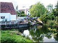
Mill Pond at Bocking Bradfordstreet Mill, Braintree
At low level, the river Blackwater trickles into this mill pond, but flooding here is not unknown. The photo is taken from the River Blackwater's highest Bridge in Bradford Street.
Image: © Brenda Howard
Taken: 2 Oct 2005
0.20 miles