IMAGES TAKEN NEAR TO
Highfield Stile Road, BRAINTREE, CM7 9SD
Introduction
This page details the photographs taken nearby to Highfield Stile Road, CM7 9SD by members of the Geograph project.
The Geograph project started in 2005 with the aim of publishing, organising and preserving representative images for every square kilometre of Great Britain, Ireland and the Isle of Man.

There are currently over 7.5m images from over14,400 individuals and you can help contribute to the project by visiting https://www.geograph.org.uk
Image Map
Images are licensed for reuse under creativecommons.org/licenses/by-sa/2.0
Notes
- Clicking on the map will re-center to the selected point.
- The higher the marker number, the further away the image location is from the centre of the postcode.
Image Listing (2 Images Found)
Images are licensed for reuse under creativecommons.org/licenses/by-sa/2.0
Image
Details
Distance
1
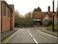
A view from Convent Lane
This is the road junction where Convent Lane meets the B1053.
Image: © Robert Edwards
Taken: 24 Feb 2010
0.22 miles
2

Franciscan Convent Chapel, Broad Road, Bocking, Braintree
The Chapel of the Immaculate Conception, is situated next to the River Blackwater and was built as an extension to Bridge House, which was bought from the Courtauld Family. It was completed in May 1899.
Image: © Brenda Howard
Taken: 2 Oct 2005
0.25 miles