IMAGES TAKEN NEAR TO
Coggeshall Road, BRAINTREE, CM7 9EW
Introduction
This page details the photographs taken nearby to Coggeshall Road, CM7 9EW by members of the Geograph project.
The Geograph project started in 2005 with the aim of publishing, organising and preserving representative images for every square kilometre of Great Britain, Ireland and the Isle of Man.

There are currently over 7.5m images from over14,400 individuals and you can help contribute to the project by visiting https://www.geograph.org.uk
Image Map (Loading...)


Getting Data...Please wait
Leaflet Map data © OpenStreetMap
Images are licensed for reuse under creativecommons.org/licenses/by-sa/2.0
Notes
- Clicking on the map will re-center to the selected point.
- The higher the marker number, the further away the image location is from the centre of the postcode.
Image Listing (9 Images Found)
Images are licensed for reuse under creativecommons.org/licenses/by-sa/2.0
Image
Details
Distance
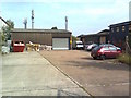
1
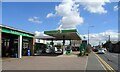
Service station on Coggeshall Road (B1256), Braintree
Image: © JThomas
Taken: 24 Aug 2022
0.06 miles
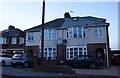
2
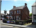
The Eagle public house, Braintree
On Coggeshall Road.
See Image] for sign.
Image: © JThomas
Taken: 24 Aug 2022
0.06 miles
3
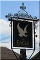
Sign for the Eagle public house, Braintree
See Image] for context.
Image: © JThomas
Taken: 24 Aug 2022
0.06 miles
9
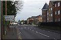
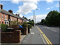
Coggeshall Road, Braintree
Approaching the junction with Courtauld Road and Railway Street, where there is a somewhat complicated double roundabout arrangement.
Image: © Stephen McKay
Taken: 31 Oct 2017
0.24 miles