IMAGES TAKEN NEAR TO
The Street, BRAINTREE, CM77 8LL
Introduction
This page details the photographs taken nearby to The Street, CM77 8LL by members of the Geograph project.
The Geograph project started in 2005 with the aim of publishing, organising and preserving representative images for every square kilometre of Great Britain, Ireland and the Isle of Man.

There are currently over 7.5m images from over14,400 individuals and you can help contribute to the project by visiting https://www.geograph.org.uk
Image Map (Loading...)


Getting Data...Please wait
Leaflet Map data © OpenStreetMap
Images are licensed for reuse under creativecommons.org/licenses/by-sa/2.0
Notes
- Clicking on the map will re-center to the selected point.
- The higher the marker number, the further away the image location is from the centre of the postcode.
Image Listing (32 Images Found)
Images are licensed for reuse under creativecommons.org/licenses/by-sa/2.0
Image
Details
Distance
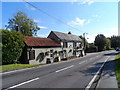
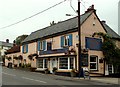
3
The Street, Black Notley, Essex
Photo shows the two village pubs - The Reindeer (nearest camera) and The Vine.
Image: © Peter Stack
Taken: 19 Sep 2010
0.03 miles
4
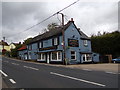
The Vine Inn Public House, Black Notley
Off The Street
https://www.vineinn.co.uk/
Image: © Geographer
Taken: 10 Oct 2019
0.04 miles
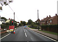
6
Witham Road, Black Notley
Near Black Notley Village Hall
Road No.C189
Image: © Geographer
Taken: 10 Oct 2019
0.08 miles
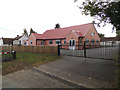
7
Black Notley Village Hall
Off Witham Road
Image: © Geographer
Taken: 10 Oct 2019
0.08 miles
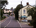
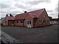
8
Black Notley Village Hall
Off Witham Road
Image: © Geographer
Taken: 10 Oct 2019
0.08 miles
9
Black Notley Village Hall
Off Witham Road
Image: © Geographer
Taken: 10 Oct 2019
0.08 miles
10
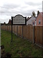
Black Notley Village Hall sign
Off Witham Road
Image: © Geographer
Taken: 10 Oct 2019
0.08 miles