IMAGES TAKEN NEAR TO
Ashes Road, BRAINTREE, CM77 8DW
Introduction
This page details the photographs taken nearby to Ashes Road, CM77 8DW by members of the Geograph project.
The Geograph project started in 2005 with the aim of publishing, organising and preserving representative images for every square kilometre of Great Britain, Ireland and the Isle of Man.

There are currently over 7.5m images from over14,400 individuals and you can help contribute to the project by visiting https://www.geograph.org.uk
Image Map
Images are licensed for reuse under creativecommons.org/licenses/by-sa/2.0
Notes
- Clicking on the map will re-center to the selected point.
- The higher the marker number, the further away the image location is from the centre of the postcode.
Image Listing (6 Images Found)
Images are licensed for reuse under creativecommons.org/licenses/by-sa/2.0
Image
Details
Distance
2
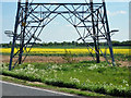
Agricultural view with pylon
The pylon is on a line heading for a large substation south of Braintree.
Image: © Robin Webster
Taken: 27 May 2013
0.15 miles
3
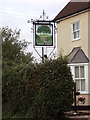
Former Three Ashes Public House sign
Off Ashes Road at the junction with Lanham Green Road
http://www.closedpubs.co.uk/essex/cressing_threeashes.html
Image: © Geographer
Taken: 10 Oct 2019
0.24 miles
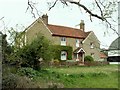
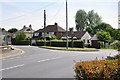
4
Former Three Ashes Public House, Cressing
Off Ashes Road at the junction with Lanham Green Road
http://www.closedpubs.co.uk/essex/cressing_threeashes.html
Image: © Geographer
Taken: 10 Oct 2019
0.24 miles
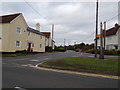
5
Junction by the Cressing village sign
Lanham Green Road and Ashes Road junction next to the Three Ashes pub.
Image: © MJ Reilly
Taken: 12 Jun 2009
0.24 miles
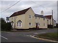
6
Lanham Green Road, Cressing
At the junction with Ashes Road & The Street
Road No.C188
Image: © Geographer
Taken: 10 Oct 2019
0.25 miles