IMAGES TAKEN NEAR TO
Kings Lane, BRAINTREE, CM77 8DD
Introduction
This page details the photographs taken nearby to Kings Lane, CM77 8DD by members of the Geograph project.
The Geograph project started in 2005 with the aim of publishing, organising and preserving representative images for every square kilometre of Great Britain, Ireland and the Isle of Man.

There are currently over 7.5m images from over14,400 individuals and you can help contribute to the project by visiting https://www.geograph.org.uk
Image Map
Images are licensed for reuse under creativecommons.org/licenses/by-sa/2.0
Notes
- Clicking on the map will re-center to the selected point.
- The higher the marker number, the further away the image location is from the centre of the postcode.
Image Listing (7 Images Found)
Images are licensed for reuse under creativecommons.org/licenses/by-sa/2.0
Image
Details
Distance
3
Stisted Mill
It used the River Blackwater, whose natural course runs just across the near field.
Image: © Robin Webster
Taken: 27 May 2013
0.16 miles
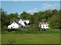
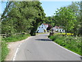
4
Footpath and road to Covenbrook Hall
The building on the right is Covenbrook Cottages.
Image: © Robert Edwards
Taken: 27 Apr 2007
0.16 miles
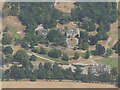
5
Bridge and Mill, Stisted
Bridge over the River Blackwater looking towards the buildings of the old Stisted Mill.
Image: © Roger Jones
Taken: 18 May 2014
0.17 miles
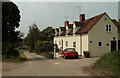
6
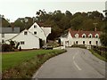
Stisted Mill, Stisted, Essex
The mill is the building in the picture, where the car is parked. It is now converted for living accommodation. These are the first buildings you see when entering Stisted from the Braintree road.
Image: © Robert Edwards
Taken: 2 Oct 2006
0.20 miles
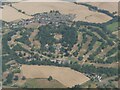
7
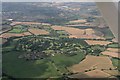
Stisted, and Braintree Golf Club: aerial 2017
Image: © Chris
Taken: 25 Aug 2017
0.20 miles