IMAGES TAKEN NEAR TO
Stisted, BRAINTREE, CM77 8BU
Introduction
This page details the photographs taken nearby to CM77 8BU by members of the Geograph project.
The Geograph project started in 2005 with the aim of publishing, organising and preserving representative images for every square kilometre of Great Britain, Ireland and the Isle of Man.

There are currently over 7.5m images from over14,400 individuals and you can help contribute to the project by visiting https://www.geograph.org.uk
Image Map (Loading...)


Getting Data...Please wait
Leaflet Map data © OpenStreetMap
Images are licensed for reuse under creativecommons.org/licenses/by-sa/2.0
Notes
- Clicking on the map will re-center to the selected point.
- The higher the marker number, the further away the image location is from the centre of the postcode.
Image Listing (2 Images Found)
Images are licensed for reuse under creativecommons.org/licenses/by-sa/2.0
Image
Details
Distance
1

Woolmer Green Farm
The road is called Lyon Hall Road.
Image: © Robert Edwards
Taken: 2 Oct 2006
0.03 miles
2
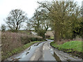
A damp Lyons Hall Road
Water runs down the lane towards a bridge over a small tributary of the Blackwater.
Image: © Robin Webster
Taken: 19 Mar 2013
0.24 miles