IMAGES TAKEN NEAR TO
Tumblers Green, BRAINTREE, CM77 8AZ
Introduction
This page details the photographs taken nearby to CM77 8AZ by members of the Geograph project.
The Geograph project started in 2005 with the aim of publishing, organising and preserving representative images for every square kilometre of Great Britain, Ireland and the Isle of Man.

There are currently over 7.5m images from over14,400 individuals and you can help contribute to the project by visiting https://www.geograph.org.uk
Image Map (Loading...)


Getting Data...Please wait
Leaflet Map data © OpenStreetMap
Images are licensed for reuse under creativecommons.org/licenses/by-sa/2.0
Notes
- Clicking on the map will re-center to the selected point.
- The higher the marker number, the further away the image location is from the centre of the postcode.
Image Listing (3 Images Found)
Images are licensed for reuse under creativecommons.org/licenses/by-sa/2.0
Image
Details
Distance
1
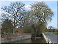
Willow and Pond, near Gower's Farm, Tumbler's Green
A weeping willow and duck pond adjoining Gower's Farm next to the road between Stisted and Tumbler's Green.
Image: © Roger Jones
Taken: 21 Apr 2013
0.09 miles
2
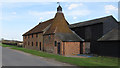
Maltings (listed building) near Gower's Farm, Tumbler's Green
Maltings, now cowhouse, square with conical roof. Early C19..
Note weathervane at apex of roof.
List entry Number: 1171412 http://list.english-heritage.org.uk/resultsingle.aspx?uid=1171412
Image: © Roger Jones
Taken: 21 Apr 2013
0.15 miles
3
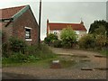
Henham's Farm, just north of Stisted, Essex
Image: © Robert Edwards
Taken: 2 Oct 2006
0.20 miles