IMAGES TAKEN NEAR TO
Ellen Way, BRAINTREE, CM77 7UU
Introduction
This page details the photographs taken nearby to Ellen Way, CM77 7UU by members of the Geograph project.
The Geograph project started in 2005 with the aim of publishing, organising and preserving representative images for every square kilometre of Great Britain, Ireland and the Isle of Man.

There are currently over 7.5m images from over14,400 individuals and you can help contribute to the project by visiting https://www.geograph.org.uk
Image Map
Images are licensed for reuse under creativecommons.org/licenses/by-sa/2.0
Notes
- Clicking on the map will re-center to the selected point.
- The higher the marker number, the further away the image location is from the centre of the postcode.
Image Listing (10 Images Found)
Images are licensed for reuse under creativecommons.org/licenses/by-sa/2.0
Image
Details
Distance
1
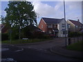
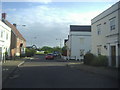
Washall Drive at the junction of Queenborough Lane
Great Notley is a new development opened by Countryside Property on April 1st 2000 and these are typical of the houses on it, which all appear to be the same mock Victorian style.
Image: © David Howard
Taken: 15 May 2012
0.14 miles
2
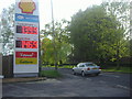
Shell garage on London Road, Great Notley
Image: © David Howard
Taken: 15 May 2012
0.18 miles
3
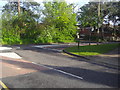
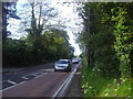
Queenborough Lane at the junction of London Road
Image: © David Howard
Taken: 15 May 2012
0.19 miles
4
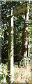
Direction Sign - Signpost on London Road, Great Notley
Lost finial - 1 arm; Maldon tapered post by the UC road, in parish of Braintree (Braintree District), London Road, junction with Queenborough Lane, may be Black Notley (only post is original).
(Refurbished by 2016)
Surveyed
Milestone Society National ID: EX_TL7421
Image: © Milestone Society
Taken: Unknown
0.22 miles
5
Bridge End Lane at the junction of Draymans Grove
These are not Georgian houses, but Elizabethan, built between 1999 and 2000
Image: © David Howard
Taken: 15 May 2012
0.23 miles
7
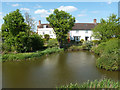
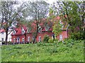
Pond, Great Notley
The house on the right is quite new, part of this large residential development, but that on the left looks as if it could be a relic from an earlier age. But no, reference to old maps shows that both houses, the pond, and the bridge from where the picture was taken are all recent creations.
Image: © Robin Webster
Taken: 27 May 2013
0.23 miles
8
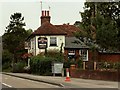
'King William IV' public house, Braintree, Essex
This pub is actually between Braintree and Black Notley on the old original A.131, now the B.1053
Image: © Robert Edwards
Taken: 23 Aug 2006
0.23 miles
9
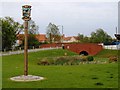
Village sign and humped-back bridge, Bridgend Lane, Great Notley
The concept of a traditional humped-back bridge was in the very first sketches for Great Notley - I know, because I came up with the idea when working for Broadway Malyan, the concept architects, in 1990/91.
Image: © John Brightley
Taken: 13 May 2004
0.24 miles
10
Housing at Draymans Grove, Great Notley
Image: © John Brightley
Taken: 13 May 2004
0.25 miles