IMAGES TAKEN NEAR TO
Stanstrete Field, BRAINTREE, CM77 7PR
Introduction
This page details the photographs taken nearby to Stanstrete Field, CM77 7PR by members of the Geograph project.
The Geograph project started in 2005 with the aim of publishing, organising and preserving representative images for every square kilometre of Great Britain, Ireland and the Isle of Man.

There are currently over 7.5m images from over14,400 individuals and you can help contribute to the project by visiting https://www.geograph.org.uk
Image Map
Images are licensed for reuse under creativecommons.org/licenses/by-sa/2.0
Notes
- Clicking on the map will re-center to the selected point.
- The higher the marker number, the further away the image location is from the centre of the postcode.
Image Listing (5 Images Found)
Images are licensed for reuse under creativecommons.org/licenses/by-sa/2.0
Image
Details
Distance
1
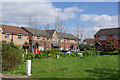
Modern housing, Great Notley
Great Notley has expanded greatly in recent years, and this is typical new housing.
Image: © Robin Webster
Taken: 18 Apr 2007
0.08 miles
2
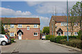
Houses on Stanstrete Field
In the newer part of Great Notley.
Image: © Robin Webster
Taken: 18 Apr 2007
0.08 miles
3

GRIDSERVE Electric vehicle charging forecourt, A131
Stood under the canopy at GRIDSERVE's Electric Forecourt location in Braintree
https://www.gridserve.com/electric-vehicle-charging/electric-forecourt/braintree/
Image: © Henners
Taken: 4 Dec 2021
0.14 miles

5

The Cricketers. Great Notley's Village Pub
Until recently this pub was a freehouse called "The Oval". It is now a Shepherd Neame Pub.
Image: © Chris Clarke
Taken: 18 Jun 2005
0.24 miles