IMAGES TAKEN NEAR TO
Pods Lane, Dunmow Road, BRAINTREE, CM77 6WF
Introduction
This page details the photographs taken nearby to Pods Lane, Dunmow Road, CM77 6WF by members of the Geograph project.
The Geograph project started in 2005 with the aim of publishing, organising and preserving representative images for every square kilometre of Great Britain, Ireland and the Isle of Man.

There are currently over 7.5m images from over14,400 individuals and you can help contribute to the project by visiting https://www.geograph.org.uk
Image Map
Images are licensed for reuse under creativecommons.org/licenses/by-sa/2.0
Notes
- Clicking on the map will re-center to the selected point.
- The higher the marker number, the further away the image location is from the centre of the postcode.
Image Listing (4 Images Found)
Images are licensed for reuse under creativecommons.org/licenses/by-sa/2.0
Image
Details
Distance
1
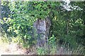
Gnarly old Oak Tree
This tree can be seen on Dunmow Road between Broads Farm and Pods Lane, one good specimen of an old gnarly barked Oak.
Image: © Simon Ashton-Jones
Taken: 20 Jun 2006
0.19 miles

3

Honeycomb Storage
Poultry sheds have been replaced by storage units on Hazelmere Farm
Image: © Glyn Baker
Taken: 29 Jun 2019
0.22 miles
4
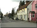
Part of The Street, in Rayne
This section of the road that runs through Rayne, is called The Street. It is part of the old Roman Road known as Stane Street that later became the original A120 that was then replaced by the present dual-carriageway that runs close by. The cream coloured building is 'The Cock' inn.
Image: © Robert Edwards
Taken: 26 Feb 2010
0.24 miles