IMAGES TAKEN NEAR TO
Dunmow Road, BRAINTREE, CM77 6SF
Introduction
This page details the photographs taken nearby to Dunmow Road, CM77 6SF by members of the Geograph project.
The Geograph project started in 2005 with the aim of publishing, organising and preserving representative images for every square kilometre of Great Britain, Ireland and the Isle of Man.

There are currently over 7.5m images from over14,400 individuals and you can help contribute to the project by visiting https://www.geograph.org.uk
Image Map (Loading...)


Getting Data...Please wait
Leaflet Map data © OpenStreetMap
Images are licensed for reuse under creativecommons.org/licenses/by-sa/2.0
Notes
- Clicking on the map will re-center to the selected point.
- The higher the marker number, the further away the image location is from the centre of the postcode.
Image Listing (7 Images Found)
Images are licensed for reuse under creativecommons.org/licenses/by-sa/2.0
Image
Details
Distance
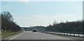
1
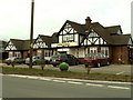
'Palm Trees' restaurant, Blake End, Essex
This restaurant was formerly, 'The Saling Oak'. It stands about 2km west of the village of Rayne on the old A120.
Image: © Robert Edwards
Taken: 19 Mar 2006
0.05 miles
2
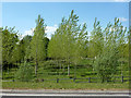
Small plantation, Blake End
Believed to be poplars.
Image: © Robin Webster
Taken: 27 May 2013
0.11 miles
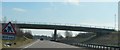
3
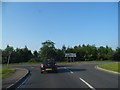
Braintree Road at the junction of Dunmow Road
Image: © David Howard
Taken: 6 Jun 2013
0.15 miles
7
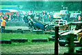
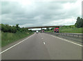
White House Farm banger racing, 1980
A bit of standard drama at the track of Braintree Auto Club. Things came to an irrecoverable end here about 2001 when a new alignment of the A120 was built straight through the middle of the site.
Image: © Robin Webster
Taken: Unknown
0.24 miles