IMAGES TAKEN NEAR TO
Rayne, BRAINTREE, CM77 6SD
Introduction
This page details the photographs taken nearby to CM77 6SD by members of the Geograph project.
The Geograph project started in 2005 with the aim of publishing, organising and preserving representative images for every square kilometre of Great Britain, Ireland and the Isle of Man.

There are currently over 7.5m images from over14,400 individuals and you can help contribute to the project by visiting https://www.geograph.org.uk
Image Map
Images are licensed for reuse under creativecommons.org/licenses/by-sa/2.0
Notes
- Clicking on the map will re-center to the selected point.
- The higher the marker number, the further away the image location is from the centre of the postcode.
Image Listing (6 Images Found)
Images are licensed for reuse under creativecommons.org/licenses/by-sa/2.0
Image
Details
Distance
1
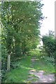
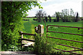
Bridleway 15-20
PROW 15-20 is 1984m long and connects the B1417/A120 junction with Frenches Green. Here it crosses the Flitch Way.
Image: © Glyn Baker
Taken: 29 Jun 2019
0.10 miles
2
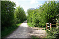
Old railway towards Dunmow
Now a trail and national Cycle Route 16.
Image: © Robin Webster
Taken: 18 Apr 2007
0.11 miles
3
End of a Joyride on the Flitch Way
I wonder if this 4x4 ended up despoiling the Flitch Way Country Park because of "taking and driving away" or an insurance fraud? here it is blocking footpath PROW 15-21 to Crix Green
Image: © Glyn Baker
Taken: 29 Jun 2019
0.13 miles
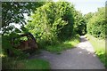
4
Footpath gate off old railway
Towards Blake End.
Image: © Robin Webster
Taken: 18 Apr 2007
0.14 miles
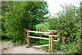
5
Footpath through the wheat
An application of paraquat or similar has made the route clear. The viewpoint is the old Bishop's Stortford - Braintree railway, now a cycle-bridleway.
Image: © Robin Webster
Taken: 18 Apr 2007
0.19 miles
6
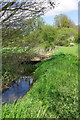
Footbridge over River Ter
The river is hardly more than a drainage ditch here. The bridge appears to be built for farm vehicles, but now unused for this.
Image: © Robin Webster
Taken: 18 Apr 2007
0.21 miles