IMAGES TAKEN NEAR TO
The Street, BRAINTREE, CM77 6RS
Introduction
This page details the photographs taken nearby to The Street, CM77 6RS by members of the Geograph project.
The Geograph project started in 2005 with the aim of publishing, organising and preserving representative images for every square kilometre of Great Britain, Ireland and the Isle of Man.

There are currently over 7.5m images from over14,400 individuals and you can help contribute to the project by visiting https://www.geograph.org.uk
Image Map
Images are licensed for reuse under creativecommons.org/licenses/by-sa/2.0
Notes
- Clicking on the map will re-center to the selected point.
- The higher the marker number, the further away the image location is from the centre of the postcode.
Image Listing (33 Images Found)
Images are licensed for reuse under creativecommons.org/licenses/by-sa/2.0
Image
Details
Distance
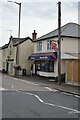
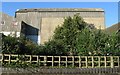
2

Rayne - Iron Foundry Chimney
Not the most scenic view around Rayne but an important part of our history. The former Rayne Iron Foundry was a major local employer over many years and features on the Village Shield.
The factory closed some years ago and the site is now, in June 2008, being demolished ahead of redevelopment for housing and offices.
Image: © Trevor Wright
Taken: 14 Nov 2005
0.03 miles
3
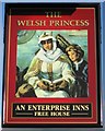
Rayne - The Welsh Princess Public House, Sign
"The Welsh Princess" Public House is located in the centre of the village. It was originally called The Cherry Tree and was to have been renamed to The Princess Diana but this was not permitted hence its current name.
Image: © Trevor Wright
Taken: Unknown
0.06 miles
4
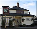
Rayne - The Welsh Princess Public House
"The Welsh Princess" Public House is located in the centre of the village. It was originally called The Cherry Tree and was to have been renamed to The Princess Diana but this was not permitted hence its current name.
This picture was taken in November 2005. During the summer all the village pubs are decorated with flowers.
Image: © Trevor Wright
Taken: Unknown
0.06 miles
5
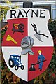
Rayne Village Shield
The Rayne Village Shield hangs from a post in the middle of the village and
depicts aspects of village history, including agriculture and the, now
closed, iron foundry works.
Top left: the spinning wheel and straw plait represent past industry, i.e. wool yarn spinning, weaving and straw plaiting,
Top right: the plough share represents the first improved plough made at Rayne Foundry with other agricultural implements,
Bottom left: a modern Tractor representing today's industry of farming and agriculture,
Bottom right: showing the filling of a mould, representing techniques once used when there was a working Foundry in Rayne, and
Centre: Sir Giles Capel's Helmet, representing our historic background.
Sir Giles wore the helmet when he jousted in feats of arms as a Knight of King Henry VIII. In his will Sir Giles directed that his best helmet and arming sword should be set above his "funeralls" and for nearly 300 years the helmet hung on an iron bar over his altar-shaped tomb in All Saints Church. When the church was pulled down in 1840 all the Capel tombs were destroyed and the helmet was removed by the builder, William Parmenter of Bocking. It was found with another on a peg in his workshop by a Miss Courtauld, later Madame Arendrup. She bought it and gave it to Baron de Cosson, the then greatest living authority on the history of arms and armour. It was exhibited in London and later acquired by the Metropolitan Museum of New York who sent the copy back to England.
Image: © Trevor Wright
Taken: Unknown
0.07 miles
6
Former Haslers Grain Store Building, Rayne, Essex
The former Grain Store run by Haslers Ltd which later became a site for numerous small businesses. The concrete wall is the face of the grain storage tanks. The building was demolished and the site cleared in December 2006. Knight Developments Ltd created a small housing estate in 2007, named "Granary Halt" accessible via Station Road.
Image: © Trevor Wright
Taken: 27 Oct 2005
0.11 miles
7
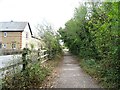
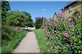
National Cycle Route 16
On the former Bishop's Stortford to Braintree railway line near the former Station House, Rayne.
Image: © JThomas
Taken: 24 Aug 2022
0.11 miles
8
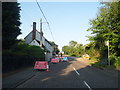
Road works on The Street, Rayne
The Street is part of the Roman Road Stane Street, running between Dunmow and Braintree.
Image: © David Howard
Taken: 6 Jun 2013
0.11 miles
9
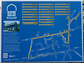
Rayne Heritage Trail Walk Map at the former Rayne Railway Station
Rayne has a rich heritage with All Saints Church as a centre for its community for over 1,000 years.
The Rayne Heritage Trail offers a circular walking route that highlights some of the 67 Grade I and II listed structures in Rayne. The route is considered "easy" walking. However, there are some uneven surfaces where caution is advised.
As the majority of the premises on the Heritage Trail are privately owned, visitors are reminded that they should remain on the public footpaths and not enter private driveways or gardens. If taken at a reasonable pace, the trail walk should take approximately 75 minutes.
Heritage Trail maps, as shown here, are located at positions around the village including here at the former Rayne Station, which is now the Booking Hall Cafe and the Carriage Museum.
For more information see the Rayne Heritage website [https://www.rayne-heritage.info/]
Image: © Trevor Wright
Taken: 22 Oct 2023
0.12 miles
10
The Flitch Way in Rayne
Here The Flitch Way Country Park http://www.visitparks.co.uk/places/flitch-way/ is a well surfaced multi use path. I am not sure if their ever was a level crossing at this point on the old railway. The road that crosses the right of way leads to a new development.
Image: © Glyn Baker
Taken: 29 Jun 2019
0.12 miles