IMAGES TAKEN NEAR TO
Leyside, BRAINTREE, CM77 6DE
Introduction
This page details the photographs taken nearby to Leyside, CM77 6DE by members of the Geograph project.
The Geograph project started in 2005 with the aim of publishing, organising and preserving representative images for every square kilometre of Great Britain, Ireland and the Isle of Man.

There are currently over 7.5m images from over14,400 individuals and you can help contribute to the project by visiting https://www.geograph.org.uk
Image Map
Images are licensed for reuse under creativecommons.org/licenses/by-sa/2.0
Notes
- Clicking on the map will re-center to the selected point.
- The higher the marker number, the further away the image location is from the centre of the postcode.
Image Listing (16 Images Found)
Images are licensed for reuse under creativecommons.org/licenses/by-sa/2.0
Image
Details
Distance
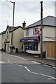
1
Rayne Primary School
All quiet on a bank holiday Monday.
Image: © Robin Webster
Taken: 27 May 2013
0.06 miles
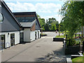
2
Path from Duckend Green to Capel Road
This part, with the local primary school on the right, is not a public footpath, but is used as such. The legal route goes round the other side of the school, squeezing through housing development, and is very pokey.
Image: © Robin Webster
Taken: 27 May 2013
0.08 miles
3
Path from Duckend Green to Capel Road
This part, with the local primary school on the right, is not a public footpath, but is used as such. The legal route goes round the other side of the school, squeezing through housing development, and is very pokey.
Image: © Robin Webster
Taken: 27 May 2013
0.09 miles
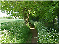
4
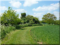
Footpath towards Duckend Green
From Capel Road, Rayne.
Image: © Robin Webster
Taken: 27 May 2013
0.11 miles
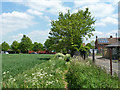
5

Rayne - The Cock Public House, Sign
"The Cock" Public House is located at the western end of the village.
Image: © Trevor Wright
Taken: 13 Nov 2005
0.15 miles
6
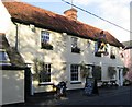
Rayne - The Cock Public House
"The Cock" Public House is located at the western end of the village.
This picture was taken in November 2005. During the summer all the village pubs are decorated with flowers.
Image: © Trevor Wright
Taken: Unknown
0.15 miles
7
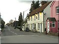
Part of The Street, in Rayne
This section of the road that runs through Rayne, is called The Street. It is part of the old Roman Road known as Stane Street that later became the original A120 that was then replaced by the present dual-carriageway that runs close by. The cream coloured building is 'The Cock' inn.
Image: © Robert Edwards
Taken: 26 Feb 2010
0.17 miles
8
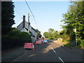
Road works on The Street, Rayne
The Street is part of the Roman Road Stane Street, running between Dunmow and Braintree.
Image: © David Howard
Taken: 6 Jun 2013
0.17 miles
9

Rayne - Iron Foundry Chimney
Not the most scenic view around Rayne but an important part of our history. The former Rayne Iron Foundry was a major local employer over many years and features on the Village Shield.
The factory closed some years ago and the site is now, in June 2008, being demolished ahead of redevelopment for housing and offices.
Image: © Trevor Wright
Taken: 14 Nov 2005
0.18 miles