IMAGES TAKEN NEAR TO
Church Lane, BRAINTREE, CM7 5XE
Introduction
This page details the photographs taken nearby to Church Lane, CM7 5XE by members of the Geograph project.
The Geograph project started in 2005 with the aim of publishing, organising and preserving representative images for every square kilometre of Great Britain, Ireland and the Isle of Man.

There are currently over 7.5m images from over14,400 individuals and you can help contribute to the project by visiting https://www.geograph.org.uk
Image Map
Images are licensed for reuse under creativecommons.org/licenses/by-sa/2.0
Notes
- Clicking on the map will re-center to the selected point.
- The higher the marker number, the further away the image location is from the centre of the postcode.
Image Listing (8 Images Found)
Images are licensed for reuse under creativecommons.org/licenses/by-sa/2.0
Image
Details
Distance
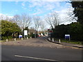
1
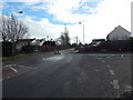
Church Meadows mini roundabout
Off Church Lane.
Image: © Hamish Griffin
Taken: 25 Jan 2015
0.05 miles
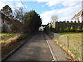
2
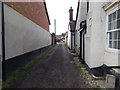
Eagle Lane
A small dead end track off Church Lane.
Image: © Hamish Griffin
Taken: 25 Jan 2015
0.18 miles
3
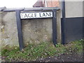
Eagle Lane sign
See Image for the rest of the street.
Image: © Hamish Griffin
Taken: 25 Jan 2015
0.18 miles
4
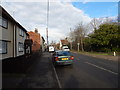
Church Lane
From the Colchester Institute junction.
Image: © Hamish Griffin
Taken: 25 Jan 2015
0.19 miles
5
Colchester Institute entrance
From Church Lane.
Image: © Hamish Griffin
Taken: 25 Jan 2015
0.21 miles
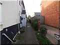
6
Wordsworth Road
A small dead end road off Church Lane.
Image: © Hamish Griffin
Taken: 25 Jan 2015
0.22 miles
8
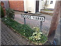
Faggot Yard sign
See Image for the rest of the street.
Image: © Hamish Griffin
Taken: 25 Jan 2015
0.23 miles