IMAGES TAKEN NEAR TO
Church Lane, BRAINTREE, CM7 5SF
Introduction
This page details the photographs taken nearby to Church Lane, CM7 5SF by members of the Geograph project.
The Geograph project started in 2005 with the aim of publishing, organising and preserving representative images for every square kilometre of Great Britain, Ireland and the Isle of Man.

There are currently over 7.5m images from over14,400 individuals and you can help contribute to the project by visiting https://www.geograph.org.uk
Image Map (Loading...)


Getting Data...Please wait
Leaflet Map data © OpenStreetMap
Images are licensed for reuse under creativecommons.org/licenses/by-sa/2.0
Notes
- Clicking on the map will re-center to the selected point.
- The higher the marker number, the further away the image location is from the centre of the postcode.
Image Listing (33 Images Found)
Images are licensed for reuse under creativecommons.org/licenses/by-sa/2.0
Image
Details
Distance
1
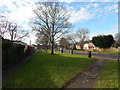
Path from Church Lane
Looking onto Coldnailhurst Avenue.
Image: © Hamish Griffin
Taken: 25 Jan 2015
0.03 miles
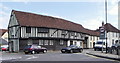
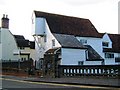
2
Former Six Bells pub, Bocking
A 1930s building, it closed as a pub in 1988. It replaced an earlier building that was demolished in 1932. There had been a pub here since about 1500.
Image: © Robin Webster
Taken: 19 Mar 2013
0.04 miles
3
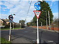
Coldnailhurst Road at the junction of Church Lane
Image: © David Howard
Taken: 6 Jun 2013
0.04 miles
4
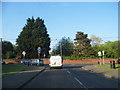
Mini-roundabout at Coldnailhurst Avenue junction
On Church Lane (B1053).
Image: © Hamish Griffin
Taken: 25 Jan 2015
0.04 miles
5
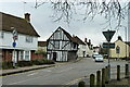
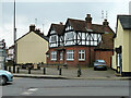
Bradford Street, Bocking
The building brazenly showing its timbers is early 16th century, grade II*(star) listed.
Image: © Robin Webster
Taken: 19 Mar 2013
0.05 miles
7
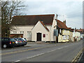
Salem Strict and Particular Baptist Chapel, Bocking
On Bradford Street.
Image: © Robin Webster
Taken: 19 Mar 2013
0.07 miles
8
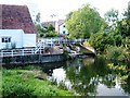
Mill Pond at Bocking Bradfordstreet Mill, Braintree
At low level, the river Blackwater trickles into this mill pond, but flooding here is not unknown. The photo is taken from the River Blackwater's highest Bridge in Bradford Street.
Image: © Brenda Howard
Taken: 2 Oct 2005
0.09 miles
9
Bocking Bradfordstreet Mill, Bocking, Braintree
Most recently used for making pellets and cubes for animal feed but no longer water powered. It is at this point that the road changes from Bradford Street, to Broad Road, and the river changes its name from Blackwater to Pant.
Image: © Brenda Howard
Taken: 2 Oct 2005
0.09 miles
10

View south-west from Bradford Bridge, Bocking
The cream-painted building (right of centre) is the subject of Image In that picture, the street-front looks Georgian (and quite urban) but it's clear from the end elevation that the corniced façade was added to an earlier gambrel-roofed building. There also appears to be a timber-framed range (with jettied first-floor) - running back at right-angles to the road.
I'm in a bit of a quandary as to the street name. The OS calls this stretch Convent Hill, but it also seems to be known locally as Bradford Street.
The bridge crosses the River Blackwater, or Pant, as it is known in its upper reaches - information gleaned from Brenda Howard's contributions: http://www.geograph.org.uk/photo/60598 http://www.geograph.org.uk/photo/60611
Image: © Stefan Czapski
Taken: 14 Aug 2015
0.09 miles