IMAGES TAKEN NEAR TO
Hadley Close, BRAINTREE, CM7 5LP
Introduction
This page details the photographs taken nearby to Hadley Close, CM7 5LP by members of the Geograph project.
The Geograph project started in 2005 with the aim of publishing, organising and preserving representative images for every square kilometre of Great Britain, Ireland and the Isle of Man.

There are currently over 7.5m images from over14,400 individuals and you can help contribute to the project by visiting https://www.geograph.org.uk
Image Map
Images are licensed for reuse under creativecommons.org/licenses/by-sa/2.0
Notes
- Clicking on the map will re-center to the selected point.
- The higher the marker number, the further away the image location is from the centre of the postcode.
Image Listing (4 Images Found)
Images are licensed for reuse under creativecommons.org/licenses/by-sa/2.0
Image
Details
Distance
1
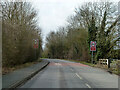
Start of 30 limit, Bocking Churchstreet
On Church Street.
Image: © Robin Webster
Taken: 19 Mar 2013
0.19 miles
2
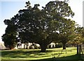
A pair of old oaks
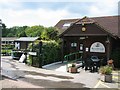
These fine trees are at Roundwood Centre that has a horticulture unit and a cafe open to the public and run as training centre for adults with special needs.
Image: © sarah white
Taken: 2 Nov 2006
0.24 miles
3
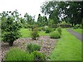
Wildlife Area and Arboretum
A newly planted native species Arboretum and wildlife area at Roundwood Garden Centre.
Image: © Stephen Rolls
Taken: 5 Jun 2006
0.24 miles