IMAGES TAKEN NEAR TO
Shalford, BRAINTREE, CM7 5JB
Introduction
This page details the photographs taken nearby to CM7 5JB by members of the Geograph project.
The Geograph project started in 2005 with the aim of publishing, organising and preserving representative images for every square kilometre of Great Britain, Ireland and the Isle of Man.

There are currently over 7.5m images from over14,400 individuals and you can help contribute to the project by visiting https://www.geograph.org.uk
Image Map
Images are licensed for reuse under creativecommons.org/licenses/by-sa/2.0
Notes
- Clicking on the map will re-center to the selected point.
- The higher the marker number, the further away the image location is from the centre of the postcode.
Image Listing (4 Images Found)
Images are licensed for reuse under creativecommons.org/licenses/by-sa/2.0
Image
Details
Distance
1
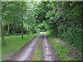
Track to Lone's Hole, Shalford
Track, which becomes a private road leading to Lone's Hole, Shalford.
Image: © Roger Jones
Taken: 16 Jun 2013
0.02 miles
2
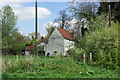
Codham Mill
A view showing the buildings behind the mill building.
Image: © Robin Webster
Taken: 18 Apr 2007
0.18 miles
3
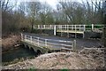
Ford at Codham Mill, Shalford
This is the second of the two fords on the River Pant at Shalford.
Image: © John Walton
Taken: 9 Feb 2013
0.21 miles
4
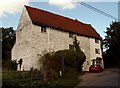
Codham Mill, west of Beazley End, Essex
This mill closed in 1956. The building is unusual in having the weather-boarded mill and the brick mill house under one roof.
Image: © Robert Edwards
Taken: 8 Sep 2006
0.21 miles