IMAGES TAKEN NEAR TO
The Street, BRAINTREE, CM7 5DR
Introduction
This page details the photographs taken nearby to The Street, CM7 5DR by members of the Geograph project.
The Geograph project started in 2005 with the aim of publishing, organising and preserving representative images for every square kilometre of Great Britain, Ireland and the Isle of Man.

There are currently over 7.5m images from over14,400 individuals and you can help contribute to the project by visiting https://www.geograph.org.uk
Image Map
Images are licensed for reuse under creativecommons.org/licenses/by-sa/2.0
Notes
- Clicking on the map will re-center to the selected point.
- The higher the marker number, the further away the image location is from the centre of the postcode.
Image Listing (25 Images Found)
Images are licensed for reuse under creativecommons.org/licenses/by-sa/2.0
Image
Details
Distance
1
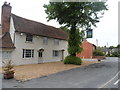
White Hart, Great Saling
This is the White Hart, Great Saling. Opposite it on the green is an unusual mini pillbox see Image
Image: © Glyn Baker
Taken: 28 Sep 2007
0.01 miles
2

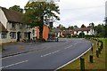
Main Road through Great Saling
The road to the right is Pickotts Lane
Image: © PAUL FARMER
Taken: 22 Aug 2010
0.01 miles
3
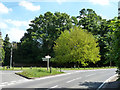
Road junction, Great Saling
Shalford and Village Hall left, Rayne and Braintree round to the right, Great Bardfield behind the camera.
Image: © Robin Webster
Taken: 27 May 2013
0.02 miles
4
So Near...
An unusual mini pill box, only a couple of metres square. I assume it was guarding the road to Andrews Field airfield. It must have been exquisite torture for those manning the box, not just the cramped conditions but to be standing looking directly across at the pub Image ... cruel and unusual punishment?
Image: © Glyn Baker
Taken: 28 Sep 2007
0.02 miles
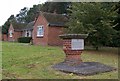
6
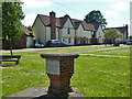
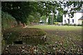
Vicarage Close
Houses surround a green, with a monument to nearby US army activity in the foreground. For full details of the plaque, see Image
Image: © Robin Webster
Taken: 27 May 2013
0.03 miles
8
RAF / USAAF Andrews Field, Great Saling
Andrews Field was the first of fourteen "Type A" airfields built by the USAAF in the U.K. during World War II. Originally designated as Great Saling when designed and under construction, the base was renamed "Andrews Field" in honour of USAAF General Frank M. Andrews, who was killed in an airplane crash in Iceland in May 1943. Andrews Field was known as USAAF Station AAF-485 and had the Station Code "GZ" Andrews Field was first occupied in May 1943, by the 4th Bombardment Wing's, 96th Bombardment Group (H), with four Squadrons of Flying Fortress's. The 96th appears to have only carried out one mission while posted to Andrews Field. Replacing them after only a short stay was the 3rd Bombardment Wing's 322nd Bombardment Group (M) which flew the Martin B-26 Marauder medium bomber. The 322nd flew its last mission on 24th April 1945.
A B-26, "Flak Bait" survived the war to the end of hostilities with 202 missions to its credit, the only USAAF aircraft to exceed 200.
After being transferred back to the Air Ministry in late 1944, it was used briefly by RAF Fighter Command for Gloster Meteor jet fighter testing before being finally closed in late 1945.
The plaque https://www.geograph.org.uk/photo/577252
Image: © Adrian S Pye
Taken: 3 Dec 2019
0.04 miles
9
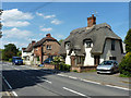
Cottages, Great Saling
Rather a small village to be called 'Great'.
Image: © Robin Webster
Taken: 27 May 2013
0.04 miles
10
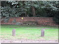
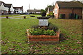
Andrews Field Memorial
This is the memorial to those who served at Image airfield in WW2. It is on the green in Victoria Close. For the dedication see Image
Image: © Glyn Baker
Taken: 28 Sep 2007
0.04 miles