IMAGES TAKEN NEAR TO
Beslyns Road, BRAINTREE, CM7 4TG
Introduction
This page details the photographs taken nearby to Beslyns Road, CM7 4TG by members of the Geograph project.
The Geograph project started in 2005 with the aim of publishing, organising and preserving representative images for every square kilometre of Great Britain, Ireland and the Isle of Man.

There are currently over 7.5m images from over14,400 individuals and you can help contribute to the project by visiting https://www.geograph.org.uk
Image Map
Images are licensed for reuse under creativecommons.org/licenses/by-sa/2.0
Notes
- Clicking on the map will re-center to the selected point.
- The higher the marker number, the further away the image location is from the centre of the postcode.
Image Listing (9 Images Found)
Images are licensed for reuse under creativecommons.org/licenses/by-sa/2.0
Image
Details
Distance
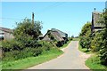
1
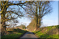
Beslyns Road
Heading towards Beslyns.
Image: © Robin Webster
Taken: 30 Dec 2014
0.13 miles
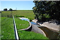
3
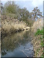
River Pant
River Pant at the weir near Bardfield
Image: © Geoff Holland
Taken: 17 Mar 2007
0.19 miles
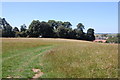
4
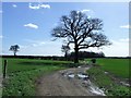
Tree And Footpath
Tree and footpath near to Great Bardfield, Essex.
Image: © Keith Evans
Taken: 21 Mar 2017
0.21 miles
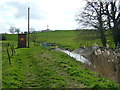
5
The River Pant
The weir here is connected with the functioning of the nearby river gauging station.
Image: © Trevor Harris
Taken: 26 Jun 2011
0.22 miles
6
Approaching Beslyns
Taken from the footpath from Finchingfield. Beslyns is the cluster of buildings to the right.
Image: © Trevor Harris
Taken: 26 Jun 2011
0.23 miles
7
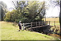
Footbridge over the River Pant
On the footpath heading for Great Bardfield.
Image: © Trevor Harris
Taken: 26 Jun 2011
0.23 miles
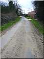
9
Cook's Lane
Looking along Cook's Lane from the road junction at Beslyns.
Image: © Trevor Harris
Taken: 26 Jun 2011
0.24 miles