IMAGES TAKEN NEAR TO
Cornish Hall End, BRAINTREE, CM7 4HG
Introduction
This page details the photographs taken nearby to CM7 4HG by members of the Geograph project.
The Geograph project started in 2005 with the aim of publishing, organising and preserving representative images for every square kilometre of Great Britain, Ireland and the Isle of Man.

There are currently over 7.5m images from over14,400 individuals and you can help contribute to the project by visiting https://www.geograph.org.uk
Image Map
Images are licensed for reuse under creativecommons.org/licenses/by-sa/2.0
Notes
- Clicking on the map will re-center to the selected point.
- The higher the marker number, the further away the image location is from the centre of the postcode.
Image Listing (7 Images Found)
Images are licensed for reuse under creativecommons.org/licenses/by-sa/2.0
Image
Details
Distance
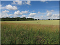
1
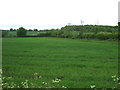
Crop field near Lopham's Farm
Off the B1057.
Image: © JThomas
Taken: 20 May 2017
0.13 miles
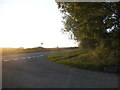
3
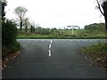
Road Junction
Road junction near to Cornish Hall End, Essex.
Image: © Keith Evans
Taken: 24 Oct 2017
0.16 miles
4
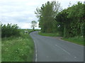
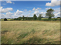
Road junction on the B1057 near Lopham's Farm
Looking north west.
Image: © JThomas
Taken: 20 May 2017
0.16 miles
7
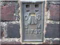
Ordnance Survey Flush Bracket 11730
This can be found on the wall of a building at Lopham's Farm.
For more detail see : http://www.bench-marks.org.uk/bm12925
Image: © Peter Wood
Taken: 25 Feb 2015
0.19 miles