IMAGES TAKEN NEAR TO
Saffron Close, BRAINTREE, CM7 4EY
Introduction
This page details the photographs taken nearby to Saffron Close, CM7 4EY by members of the Geograph project.
The Geograph project started in 2005 with the aim of publishing, organising and preserving representative images for every square kilometre of Great Britain, Ireland and the Isle of Man.

There are currently over 7.5m images from over14,400 individuals and you can help contribute to the project by visiting https://www.geograph.org.uk
Image Map
Images are licensed for reuse under creativecommons.org/licenses/by-sa/2.0
Notes
- Clicking on the map will re-center to the selected point.
- The higher the marker number, the further away the image location is from the centre of the postcode.
Image Listing (53 Images Found)
Images are licensed for reuse under creativecommons.org/licenses/by-sa/2.0
Image
Details
Distance
1

United Reformed chapel, Wethersfield
The plaque reads " rebuilt 1822" see http://www.wethersfield-essex.co.uk/urcpages/morescan1a.htm for a history of non-conformism in Wethersfield.
Image: © Bikeboy
Taken: 9 Jun 2013
0.02 miles
2
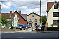
United Reformed Church, Wethersfield
Rebuilt 1822, a grade II listed building, the red brick building on the left was a Sunday school.
Image: © Robin Webster
Taken: 12 Jul 2020
0.02 miles
3
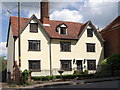
House on Silver Street, Wethersfield, Essex
Image: © nick macneill
Taken: 30 Jun 2011
0.04 miles
4
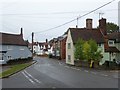
Looking down Silver Street, Wethersfield
Pevsner in 'The Buildings of England: Essex' says of Wethersfield:- "The village of Wethersfield, though less celebrated than Finchingfield, is in its way just as satisfying. Whereas Finchingfield is very concentrated, Wethersfield is spread out and runs up and down divers hills. The centre is the triangular Green at the apex of which lies the churchyard."
This view from the green looks along Silver Street which is the road to Finchingfield.
Image: © Marathon
Taken: 12 Oct 2019
0.04 miles
5
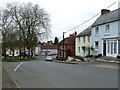
Wethersfield's High Street
High Street Wethersfield, Essex.
Image: © Keith Evans
Taken: 4 Apr 2017
0.04 miles
6
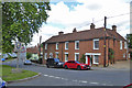
Houses on the green, Wethersfield
Early 19th century, grade II listed.
Image: © Robin Webster
Taken: 12 Jul 2020
0.04 miles
7
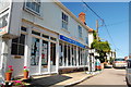
Tillbrooks - still there
This is Sunday but it looks as if the wayside pumps are still in operation.
Image: © Trevor Harris
Taken: 26 Jun 2011
0.04 miles
8
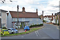
House on corner, Wethersfield
Grade II listed, 16th century with later extensions.
Image: © Robin Webster
Taken: 12 Jul 2020
0.05 miles
9
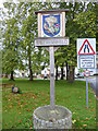
On the green at Wethersfield
Pevsner in 'The Buildings of England: Essex' says of Wethersfield:- "The village of Wethersfield, though less celebrated than Finchingfield, is in its way just as satisfying. Whereas Finchingfield is very concentrated, Wethersfield is spread out and runs up and down divers hills. The centre is the triangular Green at the apex of which lies the churchyard."
This view of the village green shows the village sign. For a close up of the sign see https://www.geograph.org.uk/photo/6295111
Image: © Marathon
Taken: 12 Oct 2019
0.05 miles
10
Village Hall, Wethersfield
The houses to the right are grade II listed, 16th century but later altered.
Image: © Robin Webster
Taken: 12 Jul 2020
0.06 miles