IMAGES TAKEN NEAR TO
School Road, BRAINTREE, CM7 4DN
Introduction
This page details the photographs taken nearby to School Road, CM7 4DN by members of the Geograph project.
The Geograph project started in 2005 with the aim of publishing, organising and preserving representative images for every square kilometre of Great Britain, Ireland and the Isle of Man.

There are currently over 7.5m images from over14,400 individuals and you can help contribute to the project by visiting https://www.geograph.org.uk
Image Map
Images are licensed for reuse under creativecommons.org/licenses/by-sa/2.0
Notes
- Clicking on the map will re-center to the selected point.
- The higher the marker number, the further away the image location is from the centre of the postcode.
Image Listing (5 Images Found)
Images are licensed for reuse under creativecommons.org/licenses/by-sa/2.0
Image
Details
Distance
2
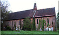
St Mary the Virgin church, Blackmore End, Essex
Closed church available for disposal in the Diocese of Chelmsford.
Image: © Peter Stack
Taken: 4 May 2012
0.08 miles
3
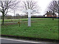
Large Finger Post
Large size finger post at Blackmore End, Essex.
Image: © Keith Evans
Taken: 23 Feb 2011
0.17 miles
5
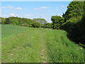
Footpath near Slotslough Bridge, Blackmore End
This public footpath runs through arable land alongside a stream close to Blackmore End.
Image: © Roger Jones
Taken: 27 May 2013
0.24 miles